
Geografia. National Oceanic and Atmospheric Administration. Meteorology. AAG Annual Meeting. AAG Annual Meeting: New York 2012 February 24–28 Getting around the Big Apple is easier than ever with a wide range of ne mobile apps on your portable device.

The AAG has assembled a list of some useful Apple and Android apps that can help you maneuver around the city, plan museum visits, find a great restaurant, book theatre tickets, or learn more about the city's history and ecology. Note: iOS refers to any mobile Apple device General Guides Food and Drink Yelp (Android, iOS) - Free Reviews of restaurants, bars, and more Opentable (Android, iOS) - Free Restaurant reservations Time Out New York (iOS) - Free Hundreds of brief reviews and suggestions by neighborhood for dining, drinking, museums, music, nightlife, and other events and sights including free and cheap events Tripadvisor (Android, iOS) - Free Planner, suggestions, and reviews on things to do, restaurants, etc.
Points of Interest. Geo Maps & Stats. Mapping & Cartography. Living Maps. Bing Maps vuelve a actualizarse con 215TB de imágenes de alta resolución. Hace menos de un mes que publicábamos la noticia referente a la actualización de la base de datos de Bing con 165TB de imágenes en alta resolución, abarcando aproximadamente unos 38 millones de km cuadrados alrededor del mundo y de todos los continentes. Ahora Bing vuelve a sorprendernos con otra actualización todavía más grande, y es que en este caso vuelve a añadir 215TB de datos al servicio con imágenes aéreas de Estados Unidos, Europa, Australia, Nueva Zelanda y Tokyo. Geography and science. n02_sean-heavey.jpg (JPEG Image, 990x567 pixels) The Mind-Blowing Mount Roraima - All That Is Interesting - StumbleUpon.
Mount Roraima is the highest of the Pakaraima mountain chain in South America and one of the world’s most extraordinary natural geological formations.

The 31 square kilometer summit area of Mount Roraima is defined by 400 meter tall cliffs on all sides and includes the borders of Brazil, Venezuela, and Guyana. The tabletop mountains of the Pakaraima’s are considered some of the oldest geological formations on Earth, dating back to over two billion years ago. The result is the staggering landscape of Mount Rariama which we tour below in photographs and video: Los cables submarinos que llevan internet a todo el mundo. Tags: Cables submarinosFibra ópticaInternet La creciente utilización de dispositivos móviles para conectarse a internet puede llevar a pensar que el flujo de la red se está trasladando a las antenas y los satélites.

Pero los datos muestran otra realidad bien distinta. Las venas que garantizan el funcionamiento mundial de la banda ancha, en realidad, se mueven por debajo del agua en cables de fibra óptica que cruzan océanos, mares y lagos. Webcams. Strange Map. Population 7 Billion. One day in Delft in the fall of 1677, Antoni van Leeuwenhoek, a cloth merchant who is said to have been the long-haired model for two paintings by Johannes Vermeer—“The Astronomer” and “The Geographer”—abruptly stopped what he was doing with his wife and rushed to his worktable.

Cloth was Leeuwenhoek’s business but microscopy his passion. He’d had five children already by his first wife (though four had died in infancy), and fatherhood was not on his mind. “Before six beats of the pulse had intervened,” as he later wrote to the Royal Society of London, Leeuwenhoek was examining his perishable sample through a tiny magnifying glass. Its lens, no bigger than a small raindrop, magnified objects hundreds of times. Leeuwenhoek had made it himself; nobody else had one so powerful. Leeuwenhoek became a bit obsessed after that. Nobody then really had any idea; there were few censuses. Historians now estimate that in Leeuwenhoek’s day there were only half a billion or so humans on Earth. 7157010997_2a92fa603c_o.jpg (JPEG Image, 2670×1447 pixels) - Scaled (59. EL TIEMPO. Geografía. La France en relief. Old Weather - Our Weather's Past, the Climate's Future. Map. Weather Forecast & Reports - Long Range & Local.
Full Screen Weather. Weather Forecast & webcams. Weather and Meteorology. Weather. Weather. Weather. Weather. Weather. Buienradar.be - meteo / weer - Actuele neerslag, weerbericht, weersverwachting, sneeuwradar en satellietbeelden - Buienradar.be. Imagine...TV about what's really going on. Weather. Weather. Weather and Meteorology. Weather. Huricanes. Weather. Weather. Online Climate Data Directory. Bibliothèque de TSGE. OSL-Expédition 7eme continent. Maps. Berlin - Berlin Weather Forecasts. GEOGRAPHY & TRAVEL (Where) Xkcd. Maps.stamen.com. Animaciones de Geografía e Historia. Livestream webcams. Geography & Environment. ¿Cuáles son los páises más y menos conocidos del mundo?
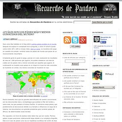
Publicado el 19/06/2012 Hace unos días hablaba en el blog sobre cuántos países existían en el mundo.

Después de explicar lo complicado de la pregunta, y cómo el número puede variar entre 187 y 205 (o incluso más), dejé un juego. La mecánica del juego en cuestión era simple: nombrar todos los países del mundo que gozan de un reconocimiento mayoritario. A bastante gente le gustó el juego, gracias a lo cuál, analizando los resultados de más de 1.300 personas que jugaron, he podido establecer una lista de cuáles son los países más y menos conocidos por aquellos que jugaron.
MAPS. Weather. Tornado Chase Live Map Interactive. Maps Online. GEOGRAPHIE. Web Cam Sites. Maps. Geography. Hours of daylight vs latitude vs day of year.png - Wikipedia, the free encyclopedia. NWS - National Mosaic Enhanced Radar Image: Full Resolution Loop. Home - Chicago Weather Center. Hourly Weather Forecast for 60647. Editor de mapas, Fabricante, OSM.
Live Streaming Webcams - Streams live in the last 24 hours. Live TV cameras on 5 continents. Webcam Network. Meteoalarm - severe weather warnings for Europe - Mainpage. Webcams. Weather. Cartography. Living Maps. Wetter. Geography. Atlas / Karten / Maps. Maps and Statistics. Huricanes. Maps. Map Collections Home Page. Weather. Geo Quizz Europe jeux flash quizz gratuits de géographie. Geo Maps & Stats. GÉOGRAPHIE. Cartes de géographie - © 1999 - 2011. Géographie-cartes.