
Group Stats Tutorial. Group Stats is a plugin for QGIS which makes it easy to calculate statistics for feature groups in a vector layer.

Note that the plugin is still marked “experimental” so you have to allow experimental plugins in order to install it. I tried this plugin for the first time today and decided to write this post because it didn’t seem immediately obvious how to use it. The plugin button is added to the vector toolbar and of course you can access it via vector menu.
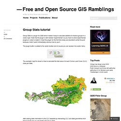
The example I want to show is: How to calculate the total area of of each Corine Land Cover (CLC) class per state. After adding state information to the CLC datasets by intersecting CLC and state geometries from Natural Earth we can get started with Group Stats. The big area on the left will display the results. To calculate the total area of of each Corine Land Cover (CLC) class per state, I chose land cover classes as columns, state names as rows and sum of areas as values: Like this: Like Loading...
ESRI’s brilliant marketing move and what Open Source GIS can learn from it « Mapoholic. ESRI has announced “ESRI Maps for Office”, an Excel add-in which will be available in public beta the first half of 2012.

So imagine: You have all your Excel data, all the power of Excel for analysis and now, you can also display this data on a map WITHIN Excel to explore and analyze it in a whole new way.Fantastic – no? It probably is. ESRI hasn’t released any information about pricing or licensing (e.g. would you need to have ArcGIS installed on the desktop to use the add-in?)
But this is beside the point. In this post, I would argue that the real story here goes far beyond of having another tool in Excel. This move by ESRI, penetrates -in a big way- a previously untapped market. In a recent blog post, Sofia Parafina, argues that the release of TileMill for Windows will be the game changer for the adoption of open source mapping. I beg to differ. …it’s rather bare bones in that there is no tool to select a feature and set the line style, color, or fill in a menu. So here we go. OSGeo & Health Workshop (#gecohealth) Invalid quantity.

Please enter a quantity of 1 or more. The quantity you chose exceeds the quantity available. Please enter your name. Please enter an email address. Please enter a valid email address. Please enter your message or comments. Please enter the code as shown on the image. Please select the date you would like to attend. Please enter a valid email address in the To: field. Please enter a subject for your message. Please enter a message. You can only send this invitations to 10 email addresses at a time. $$$$ is not a properly formatted color. Please limit your message to $$$$ characters. $$$$ is not a valid email address. Please enter a promotional code. Sold Out.
QGIS tutorials. Web mapping client comparison v.6. This comparison aims to serve as a basis for those seeking a first approach to Web mapping technologies at the client side.

In the sixth version a number of projects have been added and the whole set of clients has been categorized in order to distinguish them better, since there are currently forty four (44) Web mapping clients in the comparison. Web mapping clients play a significant role in Geoportals of Spatial Data Infrastructures (SDI) allowing the visualization of spatial data from several sources.
Likewise, these clients may be part of Web-based Geographic Information Systems (GIS) applications, in which users can directly interact with SDI services, visualize, query and integrate them with local data and GIS tools. There exists a wide variety of free and open source software (FOSS) projects that make the creation and configuration of Web mapping clients easier. Below is a graph showing the relation between free and open source Web mapping clients. Advantage, Disadvantage. OpenGeo ($ supported)