
NASA Watch. Apollo 11 - We Choose the Moon: Pre-launch. NASA. Diese Kategorie ist Teil der Grundsystematik Raumfahrt, wo auch Tipps zum Kategorisieren von Artikeln und Anlegen neuer Kategorien im Bereich Raumfahrt gegeben werden.
Diese Facettenkategorie enthält alle Artikel über NASA-Themen. Dies umfasst Personen, Einrichtungen und Raumfahrtmissionen der NASA und vieles mehr. Diese Kategorie soll keine Unterkategorien haben, eine thematische Aufteilung ist über die anderen Unterkategorien von Kategorie:Raumfahrt möglich. Siehe auch[Bearbeiten] Wikisource: NASA FACTS (englisch) Seiten in der Kategorie „NASA“ Es werden 200 von insgesamt 1.103 Seiten in dieser Kategorie angezeigt: (vorherige 200) (nächste 200)(vorherige 200) (nächste 200)
Home. Home. ASTER Imagery. Global Map NASA and Japan's Ministry of Economy, Trade and industry (METI) released the Advanced Spaceborne Thermal Emission and Reflection Radiometer (ASTER) Global Digital Elevation Model (GDEM) to the worldwide public on June 29, 2009.
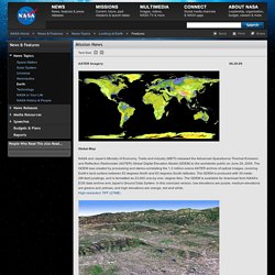
The GDEM was created by processing and stereo-correlating the 1.3 million-scene ASTER archive of optical images, covering Earth's land surface between 83 degrees North and 83 degrees South latitudes. The GDEM is produced with 30-meter (98-feet) postings, and is formatted as 23,000 one-by-one- degree tiles. The GDEM is available for download from NASA's EOS data archive and Japan's Ground Data System.
In this colorized version, low elevations are purple, medium elevations are greens and yellows, and high elevations are orange, red and white. Los Angeles Basin image Death Valley Death Valley, Calif., has the lowest point in North America, Badwater at 85.5 meters (282 feet) below sea level. Himalayan glaciers in Bhutan. ASTER GDEM. How-to (Select tiles directly) Map can be scrolled and zoomed by cursor. Zooming is possible both by mouse and scale bar on the top of the map. When clicking [# Grid] button, tiles will appear. To select tiles, press [Start] button, and click tiles by cursor.
When clicking [Clear] button or each selected tile twice, the selection is cleared. After selecting tiles, click [Next] button. How-to (Select tiles by polygon) Specify point of the polygon by cursor to select tiles. NASA Featured Images and Galleries. Launch_vernacotola.jpg (JPEG-Grafik, 1009 × 768 Pixel) NASA Earth Observatory : Home. Space, Stars, Mars, Earth, Planets and More - NASA Jet Propulsio.