
WTG: Dry Creek - Stay The Trail. Montrose County, Colorado How to Get There From Montrose: Head southwest on CO-90 W/W Main St approx 1.9 miles from Townsend Ave where it will turn into Spring Creek Rd.
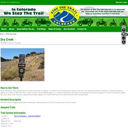
Continue on Spring Creek Rd approx 4.2 miles to 5875 Rd. Rimrocker Trail - WEST 38 MOTO – Ride and Discover. Untitled. Where To Go: Pawnee Main OHV Area. ULTIMATE RIDING DESTINATIONS: PLACES TO RIDE BEFORE YOU DIE! - Wiki Articles - Wiki. As motorcyclists, we yearn for that extra bit of excitement, to go just a bit faster, to corner just a bit better, to wheelie just a little farther…and to facilitate these activities, we seek out environments that are favorable to achieving these goals.
And some, well some are just better than others. We talked with or fellow two-wheeled travelers and tour companies to come up with just a few of the places you should ride before you die and we’ve presented them here.This certainly isn’t the definitive list of “best places” and this list only represents a bit of Central and South America, so stay tuned for many more installments in this series - but these are a damn good start if you crave a lot more seat time than just a casual afternoon ride.
Costa Rica is a small Central American country located full of incredible scenery and natural terrain such as volcanoes, jungles and beaches…and unlike in the USA and EU - most of it can be explored on two wheels. Studying The Trans America Trail - gpsKevin Adventure Rides. BAJA RALLY - HOME. Rampart Range Motorcycle Management Committee. Richard's Hollow, Card Canyon, Steel Hollow Loop. Desert daze dual sport tucson arizona riding motorcycles.
All ratings are based on using a 500+ pound Dual Sport /Adventure Motorcycle.
When you click on "gpx" a new window will open with the gpx text file written out. You may then "select all" and paste into a text file. Name the file whatever you want but be sure to end the name with .gpx instead of .txt. Instead of doing that, you can "control click" gpx and then choose "download linked file as" to download the file to your hard-drive in the location that you choose.
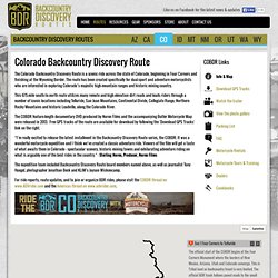
Your computer may try to append .txt to the file, don't let it. You can also click on the gpsies link to go to the gpsies site and download the gps files directly to your garmen gps device. If you need a FREE topo map of Arizona, you can download one from www.gpsfiledepot.com Download the WHOLE ENCHILADA here: WHOLE ENCHILADA GPX North West. Richard's Hollow, Card Canyon, Steel Hollow Loop. Baja Bocana B&B. Casitas de San Juanico. Utah Moto Trails - Dirt Bike, ATV Trails. Colorado Backcountry Discovery Route (COBDR) General Disclaimer; Limitation of Liability YOU ACKNOWLEDGE AND AGREE THAT THE USE OF UTBDR AND THE WEB SITE IS ENTIRELY AT YOUR OWN RISK AND THAT THE WEB SITE AND THE SERVICES ARE PROVIDED TO YOU "AS IS" WITHOUT ANY EXPRESS OR IMPLIED WARRANTIES.
COMPANY DOES NOT REPRESENT OR WARRANT THAT MATERIALS IN THE SITE OR THE SERVICES ARE ACCURATE, COMPLETE, RELIABLE, CURRENT OR ERROR-FREE. Colorado Backcountry Discovery Route (COBDR) Dust Devils Adventure Tours. European Ride Report Index. International Startpage - Worldwide Offroad News. The Motorcycle Adventures. Here are the details I handed ou. Buckhorn Directions to the Donner Pass trail head: From Masonville, CO, take CR 27 North for several miles.
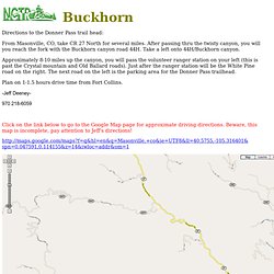
After passing thru the twisty canyon, you will you reach the fork with the Buckhorn canyon road 44H. Take a left onto 44H/Buckhorn canyon. Approximately 8-10 miles up the canyon, you will pass the volunteer ranger station on your left (this is past the Crystal mountain and Old Ballard roads). Plan on 1-1.5 hours drive time from Fort Collins. Colorado Trails, Off Road Parks, Off Road Trails, ATV Trails, Motocross Tracks. Find The Best (CO) Colorado Trails, Off Road Parks, ATV Trails and Motocross Tracks!
Are you looking for the best (CO) Colorado trails to explore? If you love taking your ATV, dirt bike or 4X4 vehicle off road and want to spend hours or even days exploring the back country then you’ve come to the right place. This state offers outdoor adventurers an almost endless an supply of every type of trail imaginable from dirt and gravel roads accessible by most stock vehicles to extreme obstacles requiring a high clearance 4x4 vehicle. More than one-third of this state is owned by the public and available for public use. In addition to the vast amount of public land available there are private off road parks open to 4x4 vehicles, ATV’s, UTV’s, side by sides as well as motocross dirt bikes. Fourmile%20Map%20REV%20sm%207%2015%2009.
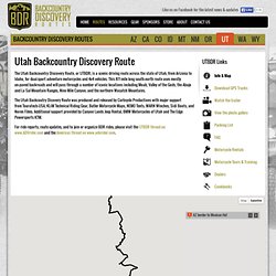
Utah Backcountry Discovery Route. General Disclaimer; Limitation of Liability YOU ACKNOWLEDGE AND AGREE THAT THE USE OF UTBDR AND THE WEB SITE IS ENTIRELY AT YOUR OWN RISK AND THAT THE WEB SITE AND THE SERVICES ARE PROVIDED TO YOU "AS IS" WITHOUT ANY EXPRESS OR IMPLIED WARRANTIES.
COMPANY DOES NOT REPRESENT OR WARRANT THAT MATERIALS IN THE SITE OR THE SERVICES ARE ACCURATE, COMPLETE, RELIABLE, CURRENT OR ERROR-FREE. COMPANY DOES NOT REPRESENT OR WARRANT THAT THE SITE OR ITS SERVERS ARE FREE OF VIRUSES OR OTHER HARMFUL COMPONENTS. Governing Law; Jurisdiction These Terms of Service are governed by the laws of the State of Washington and the United States of America, without regard to any conflict of law principles to the contrary. 2012 U.S. Dirt Bike Rides. Gravel Travel Canada. 2012 White River COHVCO Rendezvous, July 5-8, Meeker, CO. Stay The Trail Colorado - Where To Go - Stay The Trail OHV Trail Guide.
Stay The Trail Colorado - Four Mile Trail System.