
OpenStreetMap Chile EQ. Available languages — The 2010 Chile earthquake occurred off the coast of the Maule Region of Chile, on February 27, 2010, at 03:34 local time (06:34 UTC), rating a magnitude of 8.8 on the moment magnitude scale and lasting about three minutes.
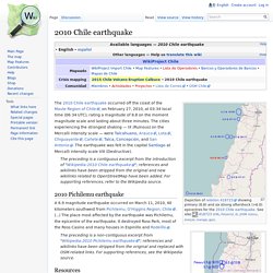
The cities experiencing the strongest shaking — IX (Ruinous) on the Mercalli intensity scale — were Talcahuano, Arauco, Lota, Chiguayante, Cañete, Talca, Concepción, and San Antonio. The earthquake was felt in the capital Santiago at Mercalli intensity scale VIII (Destructive). The preceding is a contiguous excerpt from the introduction of "Wikipedia:2010 Chile earthquake"; references and wikilinks have been stripped from the original and new wikilinks related to OpenStreetMap have been added. For supporting references, refer to the Wikipedia source. 2010 Pichilemu earthquake A 6.9 magnitude earthquake occurred on March 11, 2010, 40 kilometers southwest from Pichilemu, O'Higgins Region, Chile. (...)
Resources Use and references. Openstreetmap (openstreetmap) El Mapa Libre del Mundo. OSM2008 Vimeo. IllustrGuide Nonprofit GIS and Online Mapping. Ushahidi Chile Cómo Crear un Evento SMS, Correo El. Ushahidi (ushahidi) Project Einstein Haiti Report & The Earthqua. DigiDem chile-situation-room list... Twitter.com/DigiDem/status/9928972312. #FF Our @ushahidi-Chile si... SIPA Volunteers Take Lead on Ushahidi-Chile. Training the Ushahidi-Chile Team in a Flash. Mark Belinsky co-founded Digital Democracy with Emily Jacobi.

He serves as Technical Director and brings a background in computer science, sociology and film & media studies. He and Emily have worked closely with Burmese populations since 2007. Working in the tech sphere, it’s the power and passion that people have that never ceases to astound me. Following the Jan. 12 earthquake in Haiti, people around the world contributed an incredible outpouring of support for the people of Haiti. Now, as that support expands to Chile, it is evident that we are participating in a game changing moment.
What is Ushahidi? Net puts Kenya at centre of Chile rescue efforts. Kenya is nearly 12,000km (8,000 miles) from Chile and is therefore perhaps not an obvious place from which to try to coordinate the earthquake relief efforts.
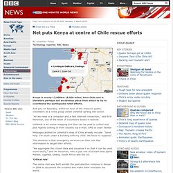
And yet, on Saturday, within an hour of the massive quake, volunteers at a crisis group called Ushahidi sprang into action. "All we need is a computer and a fast internet connection," said Erik Hersman, one of the team of volunteers based in Nairobi. Ushahidi is an online mapping tool that can be used to collect and plot reports coming in from citizens via e-mail, SMS or even Twitter. Messages plotted on Ushahidi's map of Chile already include: "Send help. I'm stuck under a building with my child. The intention is that emergency services can then use that information to target their efforts. "We aggregate the citizen data and visualise it so that it can be used more easily," said Mr Hersman, who is just one of a team that spans Malawi, Uganda, Ghana, South Africa and the US.
MediaMonitoring Ushahidi Chili. FortiusOne Visual Intelligence Solutions. FortiusOne (FortiusOne) FortiusOne GeoCommons HQ. Verifying and Filtering News (FOSS) Concepcion #Chile Street Atlas @OpenStreetMap data. Caminos Chile después del Terremoto. Mapa colaborativo de Comercio (NO EDITAR ESTE TEXTO) - Google Ma. CrisisCommons Wiki Chile/2010 2 27 EQ. En ESPAÑOL.

CrisisCommons (CrisisCommons) Tweak-the-Tweet Twitter Feed. UN-SPIDER Knowledge Portal. UN-SPIDER - full version. UN-SPIDER. UNICEF and partners stand ready to help after massive earthquake. Tsunami.gov Page. Hawaii State Civil Defense. Pacific Tsunami Warning Center's Live Feed (Chile Quake) at GeoC. Pacific Tsunami Depictions « Depiction Blog. Webcam kaart - Webcams.travel. National Data Buoy Center.
Hawaii Tsunami 2/27/10 11:44AM PST, 2/27/10 11:44AM PST al-mofo. Volcanic explosions expected in Chile quake's wake - environment. Besides aftershocks, Chile's magnitude 8.8 earthquake on 27 February may also leave a legacy of volcanic explosions.

"We expect to see an upsurge in volcanic activity over the next 12 months," says David Pyle, a volcanologist at the University of Oxford. Charles Darwin was among the first people to suggest a link between large earthquakes and increased volcanic activity. In his records, he notes that a large earthquake off Chile's coastline in February 1835 appeared to resurrect previously inactive volcanoes, and cause active ones to increase their eruption rates. Last year, Pyle and his colleagues confirmed that this was a real effect in Chile, showing that increases in volcanic activity have occurred following other large earthquakes along its coastline. Last week's earthquake occurred on the same section of fault that caused the earthquake Darwin observed in 1835. Pyle stresses that the risk to local people from this extra volcanism is likely to be minimal. Resources for Chile earthquake response. After hearing of the devastatingly powerful 8.8 magnitude earthquake that struck Chile overnight, we began to mobilize several teams to see what Google resources could help with disaster response.
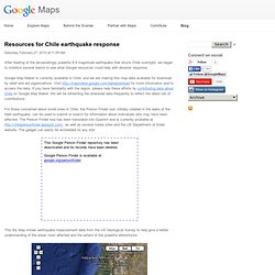
Google Map Maker is currently available in Chile, and we are making this map data available for download by relief and aid organizations. Visit for more information and to access the data. ReliefWeb Maps Chile: Earthquake - Feb 2010. Shakemap us2010tfan. USGS Geist. HOW TO: Donate to Chile Earthquake Relief Online. If you're looking to pitch in to the relief effort for Chile after this morning's massive earthquake, we've gathered some of the web's best channels for humanitarian aid and reconstruction efforts. MediaSources Chili EQ. Tv de chile on USTREAM: tv de chile . Other Entertainment. Watch without ads Ustream © Search.

Noticias Perú / CNM se recompone / Bono militar. Latercera.com. El terremoto en detalle. Video - Breaking News Videos. Chile quake moves city more than 10 feet. Earthquake also shifted other parts of South America Scientists have credited the quake with shifting the Earth's axis Despite deaths, experts see opportunities to gain valuable information in the aftermath (CNN) -- The magnitude-8.8 earthquake that rocked the west coast of Chile last month was violent enough to move the city of Concepcion at least 10 feet to the west and the capital, Santiago, about 11 inches to the west-southwest, researchers said.
The quake also shifted other parts of South America, as far apart as the Falkland Islands and Fortaleza, Brazil. The results were reached via global positioning satellite measurements taken before and after the February 27 quake by teams from The Ohio State University, the University of Hawaii, the University of Memphis and the California Institute of Technology, as well as agencies across South America.
Cruz Roja Chilena (CruzRojainforma) Maps of the Chile Earthquake - Map. SantiagoAlthough the Metropolitana region, which includes Santiago, was not struck as badly as the southern parts of the country, 38 people were killed.
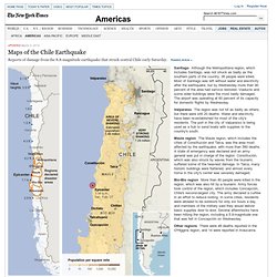
Most of Santiago was left without water and electricity after the earthquake, but by Wednesday more than 90 percent of the area had service restored. Viaducts and some older buildings were the most badly damaged. The airport was operating at 60 percent of its capacity for domestic flights by Wednesday. ValparaísoThe region was not hit as badly as others, but there were still 20 deaths. Water and electricity have been re-established for most of the city's residents. Maule regionThe Maule region, which includes the cities of Constitución and Talca, was the area most affected by the earthquake, with more than 580 deaths. Bío-Bío regionMore than 90 people were killed in the region, which was also hit by a tsunami. Other regionsThere were 48 deaths reported in the O'Higgins region, and 14 were reported in Araucanía. NYTimes Chile News (nytimeschile)
Nytimes/tsunami. Video Scramble in Chile to Save QuakeVictims. Earthquake in Chile. PersonFinder: Chile EQ. Real-time local Twitter trends. Just begin it. Help.