
How to improve our work in Haiti? MapMaker and OSM t. This is a question I’m considering a lot … filtered through the brief rushes of reading the amazing crisismappers list, diving into OSM on the wiki and IRC channel … Are we doing everything we possibly can in serving the responders? Can we coordinate our mapping work better? And once aid starts flowing and the immediate response turns to long term recovery and reconstruction, how will our process and community change, when more and more data to synchronize will be coming from the ground in Haiti?
How do we operate better in the next disaster? Big questions, and glad that many folks are already compiling ideas. Please add ideas and needs there. One immediate point that has been raised in private discussion, and now publicly, are the separate efforts of OSM and Google MapMaker in Haiti, separated by incompatible licenses. There is likely much to be gained by everyone working in the commons. What do you think? OSM/Google MapMaker comparision. 18 January, 2010 As the relief effort to the crisis in Haiti unfolds, so does response from mapping organisations with global reach. It is a positive development that free data is available from the Volunteered Geographic Information (VGI) community to assist humanitarian work on such a large scale, and good that there are now two sources. However, it is sad to discover that there seems to be friction between Google Map Maker and OpenStreetMap as to which organisation will prevail among governmental and NGO users. A key issue is surely to ascertain – and fast - which source of crowdsourced geographic information is most useful for which geographical area, and where the differences lie.
I did this assessment today, in the hope that it is useful for the emergency relief work now, and for the reconstruction work to follow. OSM and Map Maker coverage - Haiti - 18 January 2010 The file contains the total roads length for both datasets. ∑(OSM roads length)-∑(Map Maker roads length) Like this: Haitian Earthquake Emphasizes Danger of a Split Geo Community. My career has afforded me the opportunity to be part of what I believe to be a wonderful and generous community; the world geospatial community.
A typically happy group of geo-nerds armed with laptops, gps enabled gadgets, and a strong foundation of thinking spatially. Now, this community certainly has some big business motives behind it, but whenever there is a disaster, or crisis like we are seeing now in Haiti, this community comes together and throws everything it has to offer to help. It energizes me to do what I can to help in these times of need and dedicate myself to applying my trade to the cause. And as a Google employee, I'm blessed to have the full support of my management to work full time when necessary on these events.
I sat on an early conference call with representatives of all the major GIS vendors, first responders, geo-nerds, NGOs, govies, and the media where everyone brought what they could do to the table and people teamed up to go do what they do best together. The Case for Using Creative Commons Zero for Disasters. Sean Wohltman has an insightful post on the need to make the OpenStreetMap and Google MapMaker communities compatible for disasters.
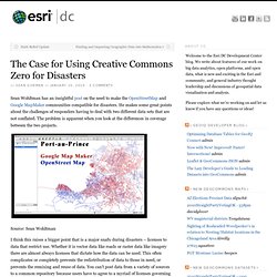
He makes some great points about the challenges of responders having to deal with two different data sets that are not conflated. The problem is apparent when you look at the differences in coverage between the two projects. Source: Sean Wohltman I think this raises a bigger point that is a major snafu during disasters – licenses to data that restrict use. Whether it is vector data like roads or raster data like imagery there are almost always licenses that dictate how the data can be used. If we can all get our lawyers to take a back seat to the greater good I’d lobby all companies, NGO’s and governments contributing data during disasters to place that data under a creative commons zero license.
Data contributors can always put a temporal limitation on the data, so the content is not abused after the disaster for other purposes.