
Part 1: Getting Started With PostGIS: An almost Idiot's Guide (PostGIS 2.0) PostGIS is an open source, freely available, and fairly OGC compliant spatial database extender for the PostgreSQL Database Management System.

In a nutshell it adds spatial functions such as distance, area, union, intersection, and specialty geometry data types to the database. PostGIS is very similar in functionality to SQL Server 2008 Spatial support, ESRI ArcSDE, Oracle Spatial, and DB2 spatial extender. The latest release version now comes packaged with the PostgreSQL DBMS installs as an optional add-on. As of this writing PostGIS 2.0.0 is the latest stable release. Noteable enhancements in this release: We will assume a windows environment for this tutorial, but most of the tutorial will apply to other supported platforms such as Linux, Unix, BSD, Mac etc. We will not go into too much detail here since the install wizard (at least the windows one) is pretty good. Note for Vista Users Because of the new added security in Vista, you may run into issues installing PostgreSQL. Putting Landsat 8’s Bands to Work. Here’s a picture of LA, just like an ordinary digital camera would take (if it had ten times as many megapixels and were in space).
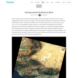
The image is only two weeks old, taken from Landsat 8, launched by NASA late this winter. Landsat 8 is already one of our favorite data sources – and not just ours: at State of the Map last weekend, it kept coming up in conversation with people from all kinds of backgrounds. More than just adding fresh true-color imagery from Landsat 8 to MapBox Satellite, we’re investing in data services using the multispectral information that the satellite provides. Its non-visual bands let us analyze everything from terrain types to crop growth to natural disasters – all around the world, sometimes within hours. This post introduces some of Landsat 8’s features, to give you a feel for what the world looks like through its lens.
Landsat 8 view of the Los Angeles area, May 13th, 2013. Landsat Data Dictionary. Band Combinations. Landsat Thematic Mapper (TM) Band 1 (0.45 - 0.52u m): provides increased penetration of water bodies and also capable of differentiating soil and rock surfaces from vegetation and for detecting cultural features.
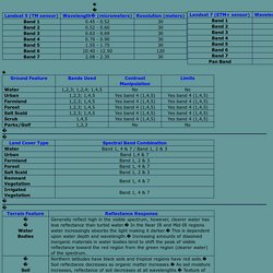
Band 2 (0.52 - 0.60u m): it is sensitive to water turbidity differences; it highlighted the turbid water in the Barkley Lake. What to do when you don't receive your item or it's not as described. We want you to be happy with your buying experience.
If you don't receive an item you paid for, or you receive an item that's significantly not as described in the listing, we're here to help with guidelines and tools for resolution. If you paid with PayPal, your purchase may also be protected with PayPal Buyer Protection. Steps to take if you don't receive an item or it's significantly not as described If you've paid for an item but not received it, or the item doesn't match the seller's description, you can follow these steps. Be aware of the timing for opening and closing cases.
You can open a case in the Resolution Centre 10-45 days after the sale (for payment outside of PayPal)The seller has up to 10 days to respond to your case.If you haven't closed it within 90 days after the end of the transaction, your case closes automatically. 1. Most problems can be solved by direct communication between buyers and sellers. 2. Note: 3. 4. 5. 6. 7.
Quick answers about the process. Processing Landsat 8 Using Open-Source Tools. This step-by-step post walks through processing Landsat 8 imagery into an interactive map that you can integrate into your website or app.
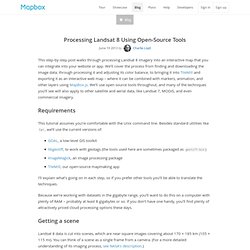
We’ll cover the process from finding and downloading the image data, through processing it and adjusting its color balance, to bringing it into TileMill and exporting it as an interactive web map – where it can be combined with markers, animation, and other layers using MapBox.js. Landsat 8 Launches. Putting Landsat 8’s Bands to Work. Band Combinations for Landsat 8. Landsat 8 has been online for a couple of months now, and the images look incredible.
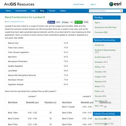
While all of the bands from previous Landsat missions are still incorporated, there are a couple of new ones, such as the coastal blue band water penetration/aerosol detection and the cirrus cloud band for cloud masking and other applications. Here’s a rundown of some common band combinations applied to Landsat 8, displayed as a red, green, blue (RGB): Landsat8. Using the USGS Landsat 8 Product. Background The standard Landsat 8 products provided by the USGS EROS Center consist of quantized and calibrated scaled Digital Numbers (DN) representing multispectral image data acquired by both the Operational Land Imager (OLI) and Thermal Infrared Sensor (TIRS).
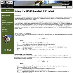
The products are delivered in 16-bit unsigned integer format and can be rescaled to the Top Of Atmosphere (TOA) reflectance and/or radiance using radiometric rescaling coefficients provided in the product metadata file (MTL file), as briefly described below. Landsat-8/LDCM - eoPortal Directory - Satellite Missions - Earthnet Online. Landsat-8 / LDCM (Landsat Data Continuity Mission) The Landsat spacecraft series of NASA represents the longest continuous Earth imaging program in history, starting with the launch of Landsat-1 in 1972 through Landsat-7 with the ETM+ imager (launch April 15, 1999).
With the evolution of the program has come an increased emphasis on the scientific utility of the data accompanied by more stringent requirements for instrument and data characterization, calibration and validation. This trend continues with LDCM, the next mission in the Landsat sequence. The enhancements of the Landsat-7 system, e.g., more on-board calibration hardware and an image assessment system and personnel, have been retained and improved, where required, for LDCM.
Landat8&7. Landsat8 vs etm+