
Home. Traditions of the Sun : Ancient Astronomy. Calendars Through The Ages. Maps. An Atlas of Cyberspaces- Historical Maps. USENET in 1981.

The topology of the BITNET in 1981 (partial map) The NSFNET infrastructure and topology in 1991. Pleiades. Old-world-map.jpg (1599×919) Ancestry5_medium.jpg (1500×768) New Hampshire Sanborn Map Collection. David Rumsey Historical Map Collection. Concharte. Interactive Historical World Atlas. Athens historical buildings, neoclassical and eclectic architecture map. Periodis Web - Maps to be Used for the History of Europe. Euratlas Periodis Web shows the history of Europe through a sequence of 21 historical maps, every map depicting the political situation at the end of each century.
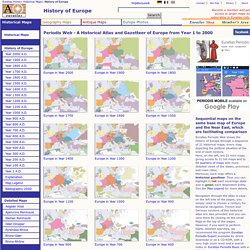
Here, on the left, are 21 mini-maps giving access to 21 full maps and to 84 quarters of maps with more detailed views of the states, provinces and main cities.Moreover, each map offers a historical gazetteer. Thus you can highlight in red each sovereign state and in green each dependent entity. See the Map Legend for more details. Navigation through the atlas is easy: on the left side of the pages, you simply need to choose a century for temporal navigation.