
Géologie, globe virtuel, Ressources pédagogiques, Enseigner les Sciences de la vie et de la Terre avec les TICE - Éducnet. Revamped Google Earth 6 Gets Trees, Historical Imagery, And More (PICTURES) Google has just introduced the newest version of Google Earth, Google Earth 6.
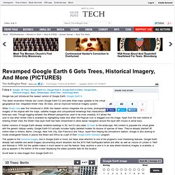
This latest incarnation follows last June's Google Earth 5.2 and adds three major updates to the virtual geographical tool: integrated Street View, 3D trees, and an improved historical imagery system. While Street View was first introduced in 2008, the newest version integrates the up-close, photographic imagery of the original with the maps, satellite images and computerized renderings that characterize the birds-eye view. Though toggling between the different perspectives used to be more unwieldy, 6.0 allows the user to see when Street View is available by highlighting roads blue when the Pegman icon is dragged over the image. Apart from the new method of entering Street View, the Street View layer itself has been streamlined to allow easier navigation around the layer with mouse or arrow keys. Earlier versions of Google Earth already rendered buildings in 3D, but 6.0 also adds 3D trees to the landscape.
Google Earth. Google Earth is a virtual globe, map and geographical information program that was originally called EarthViewer 3D created by Keyhole, Inc, a Central Intelligence Agency (CIA) funded company acquired by Google in 2004 (see In-Q-Tel).
It maps the Earth by the superimposition of images obtained from satellite imagery, aerial photography and geographic information system (GIS) 3D globe. It was originally available with three different licenses, but has since been reduced to just two: Google Earth (a free version with limited function) and Google Earth Pro ($399 per year), which is intended for commercial use.[4] The third original option, Google Earth Plus, has been discontinued.[5][6] For other parts of the surface of the Earth, 3D images of terrain and buildings are available. Google Earth uses digital elevation model (DEM) data collected by NASA's Shuttle Radar Topography Mission (SRTM).[11] This means one can view the whole earth in three dimensions. Detail[edit] Uses[edit] Mars[edit] GOOGLE EARTH. Google Earth est la toute dernière déclinaison thématique proposée par Google.
Cette application gratuite offre à tous la possibilité d’explorer le monde en 3D, de naviguer sur le globe. Un outil de visualisation donc, mais pas seulement puisqu’il intègre un moteur de recherche géographique capable de localiser un grand nombre de commerces et services, d’établissement publics ou de monuments. Un outil encore en version Beta qui se veut à la fois ludique et pratique et qui devrait faire l’objet de mises à jour et d’évolution régulières, tant au niveau des données que des fonctionnalités. Vous pouvez d’ores et déjà télécharger Google Earth sur le site officiel.
Google Earth n’est aujourd’hui disponible que pour les systèmes d’exploitation Microsoft Windows XP et 2000. Contexte Forte d’une banque de données de près de douze tera-octets d’informations géographiques, KeyHole commercialisait alors une application très similaire à Google Earth à un public composé essentiellement de professionnels.