YouTube - Broadcast Yourself. Maps and Statistics. National Geographic: Round Earth, Flat Maps. National Atlas home page. The National Map is now offering a collection of small-scale datasets that can be downloaded for free.
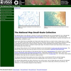
Although the 1997-2014 Edition of the National Atlas of the United States was retired in September 2014, The National Map recognizes the importance of continuing to make a collection of the small-scale datasets, originally developed for the National Atlas, available to users. Small-scale maps have an advantage over large-scale maps when there is a need to show a large area in a single view. National Geographic Maps: Tools for Adventure - Map Games - Adventure Island. Use a Compass Rose. Scribble Maps - Draw on google maps with scribblings and more! Online Interactice Maps. Oxfam - Mapping Our World: Lesson 1 - Globe Unwrapped. United States History Map . Intro. GeoGames. World Continents Quizzes. "I stumbled upon your fun interactive geography games from a link on the Massachusetts Geographic Alliance Website.
Since then, your games have become quite a hit with my competitive colleagues! " --Candice Gomes, Education Outreach Coordinator, Boston Public Library Sheppard Software's geography games were featured in the Boston Public Library's 2006 Exhibition on Mapping! Oxfam - Mapping Our World: Home. Using a Map Grid. Up2Maps - Create & share thematic data maps on GoogleMaps. SHOW®/WORLD - A New Way To Look At The World. Continents and Oceans. Interactive map. National Geographic. Map Puzzles Learn U.S. and World Geography.
Map Puzzles for all computers and devices including iPad, Android, PC and Mac: We will be updating the rest of our Map Puzzles for devices soon; these still require Adobe Flash: World Continents Map Puzzle World Features Map Puzzle.