
Area Cartogram Maps Explored. Area cartogram maps are maps of non-absolute space where the areal extent is in proportion to some measured value.
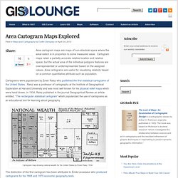
Cartogram maps retain a partially accurate relative location and relative space, but the actual area of the individual polygons features are overrepresented or underrepresented based on the assigned values. Area cartograms are useful for visualizing relativity based on a common quantitative attribute such as population. Cartograms were popularized by Erwin Raisz who published the first statistical cartograms of the United States. GISS: G.Projector — Global Map Projector. G.Projector transforms an equirectangular map image into any of over 125 global and regional map projections.
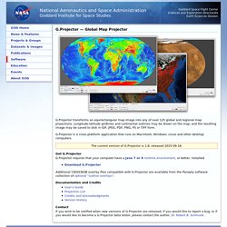
Longitude-latitude gridlines and continental outlines may be drawn on the map, and the resulting image may be saved to disk in GIF, JPEG, PDF, PNG, PS or TIFF form. G.Projector is a cross-platform application that runs on Macintosh, Windows, Linux and other desktop computers. The current version of G.Projector is 1.8, released 2015-09-18. Map Projections Poster.