
Sommaire de la cartothèque : toutes les cartes de France ici en un clic - Chroniques Cartographiques. SIT PNR. Le massif du Mont-Blanc. France. Carto n°4. La carte de France du tourisme, mois par mois - L'Internaute Voy.
France : carte du relief, altitude, topographie. Fonds de cartes. Les fonds de cartes en téléchargement ci-après sont disponibles selon les termes de la licence ouverte Etalab.
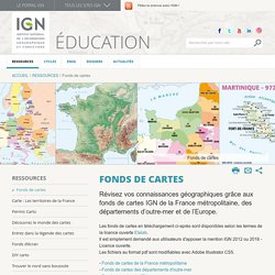
Il est simplement demandé aux utilisateurs d'apposer la mention IGN 2012 ou 2016 - Licence ouverte.Les fichiers au format pdf sont modifiables avec Adobe Illustrator CS5. - Fonds de cartes de la France métropolitaine - Fonds de cartes des départements d'outre-mer- Fonds de cartes de l'Europe Fonds de cartes de la France métropolitaine(Échelle : 1/5 400 000) Poster « Nouveau découpage des régions » Télécharger le fond de carte au format .jpg (8,6 Mo)Télécharger le fond de carte au format .ai (11 Mo)Télécharger le fond de carte au format .eps (28 Mo)Télécharger le fond de carte au format .pdf (12,5 Mo) La France, sans toponymes, avec contours de régions et de départements La France, sans toponymes et avec contours de régions La France, avec toponymes et contours de régions La France, sans toponymes et avec contours de départements La France, avec toponymes et contours de départements.
LA FRANCE DES TRENTE GLORIEUSES - Xavier Martin. Par Xavier Martin, dimanche, février 7 2010.
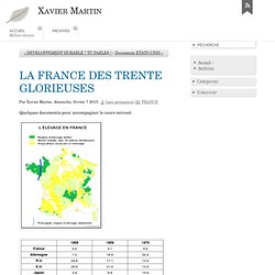
Lien permanent FRANCE Quelques documents pour accompagner le cours suivant Première partie de la carte sur l'agriculture en France. Partie statique. Il s'agit des grandes régions agricoles. Avec cette carte on dépasse la tranche chronologique des Trente Glorieuses pour aller au-delà. Géoportail - le portail des territoires et des citoyens. Petite devinette : C'est quoi ça ? Cartographie. Bêta) How Wine Became Metropolitan: An Interview with David Gissen. IMAGE: The Metro Wine Map of France, designed by David Gissen.
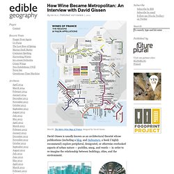
David Gissen is usually known as an architectural theorist whose publications (including a blog, and Subnature, a book I highly recommend) explore peripheral, denigrated, or otherwise overlooked aspects of urban nature — puddles, smog, and weeds — in order to re-imagine the relationship between buildings, cities, and the environment.
IMAGE: “Reconstruction of Midtown Manhattan c.1975,” and “Urban Ice Core/Indoor Air Archive,” two speculative proposals by David Gissen that reconstruct New York City as the world centre for intense indoor air-production and consider how that atmosphere might be archived. In Gissen’s own projects, he proposes a new kind of architectural preservation and reconstruction that engages with the intangibles of the urban environment. IMAGE: From “Museums of the City” by David Gissen, project rendered by Victor Hadjikyriacou. IMAGE: The 2009 Morgon by Marcel Lapierre, photo via. Gissen: Exactly. Cartogrammes : la France comme vous ne l'avez jamais vue - Journal du Net Economie.
Carte de France - atlas - Géoclip. Geoclip 3. CARTE DE FRANCE GEOGRAPHIE - Géographie CartesFrance.fr.