
TeamSurv - Home. David Rumsey Historical Map Collection. Britain from Above. Gmapcatcher - An offline map viewer. Overview GMapCatcher is an offline maps viewer.
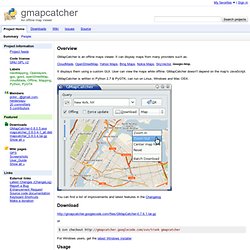
It can display maps from many providers such as: CloudMade, OpenStreetMap, Yahoo Maps, Bing Maps, Nokia Maps, SkyVector, Google Map. It displays them using a custom GUI. User can view the maps while offline. GMapCatcher is written in Python 2.7 & PyGTK, can run on Linux, Windows and Mac OSX. You can find a list of improvements and latest features in the Changelog Download or $ svn checkout gmapcatcher For Windows users, get the latest Windows installer Usage maps.py is a gui program used to browse google map. After version 0.04, user can force GMapCatcher to re-download old map tiles by checking "Force update". PLOTS Map Toolkit. The PLOTS Archive. Do-It-Yourself "satellite" imagery These maps were largely made by taking photos from balloons and kites, a technique adopted and refined by Public Lab contributors.
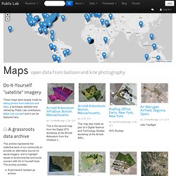
Make one yourself and it can be featured here. A grassroots data archive This archive represents the collective work of our community to provide an alternative source for aerial imagery, and to highlight issues of environmental and social concern with Do-It-Yourself tools. The archive provides: A permanent, backed up archive A place to advocate around your data A space to discuss and understand the maps. Maps.stamen.com. Leaflet - a modern, lightweight JavaScript library for interactive maps by CloudMade.
Star Wars location spotting in Tunisia. When you say Star Wars, most people think of galaxies far far away.
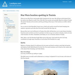
But all these exotic planets from the movies were filmed on earth. Four of the Star Wars movies were partially filmed in southern Tunisia (the planet Tatooine in the movies) and the good thing is that many of the locations are still in relative good state. You can stay in Luke Skywalker's home (now a hotel) and wander around the desert bumping into moisture vaporators and other Star Wars stuff around the Mos Espa set. Because Star wars is not well known in Tunisia, this article will introduce you to some famous locations from the movies and show you how to get there. So when you go on vacation to Tunisia, check out some of the locations over there. Free software downloads. Mapnificent - Dynamic Public Transport Travel Time Maps. A world-leading geoscience centre. Greg's Cable Map.
Grassroots Mapping. Strange Maps. Open Source Computing and GIS in the UK » Python for GIS (some links for beginners) So, I’m late to the game and only just learning about the coolness that is python.
To be honest, for years the need to keep the indents in the code neat and tidy put me off, but I figured I’d better have a proper look at some point. I spent some time over Christmas going over some tutorials (more below) and more recently I’ve chosen a python-based approach to problems where previously I would have used a different method. So far so good though no doubt my efforts will make grown coders weep… These are just a few links that I have found really useful- the first is a very good tutorial for new python users who are particularly interested in Geoprocessing, whilst the others deal with more specific problems.
Geoprocessing with Python using Open Source GIS. If anyone has any other resources for python beginners, particularly around Open Source GIS and PostgreSQL, feel free to add them in the comments. Portal. Map Maker. Google Map Maker officially closed on March 31, 2017, and many of its features are being integrated into Google Maps.
Since 2008, the Google Map Maker community has edited and moderated millions of features to improve the Google Maps experience. To make it easier for all Google Maps users to contribute changes to the map, we’ve started to graduate functionality from Map Maker to Google Maps on both desktop and mobile. Key editing features currently available in Google Maps include: We’ll continue to add new editing features within Google Maps on an ongoing basis. To keep contributing your local knowledge to Google Maps and engage with a passionate community of likeminded individuals, we invite you to join the Local Guides program where you can do things like: Glympse - Share Your Where. Welcome! - WorldMap. FREE British Isles, UK and Ireland Maps Home (talkytoaster) CloudMade Downloads.
100 Years of Set Locations - Full Screen - BoxOfficeQuant. Live Earthquake Mashup. Timemap - Project Hosting on Google Code. Timemap.js is a Javascript library to help use online maps, including Google, OpenLayers, and Bing, with a SIMILE timeline.
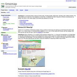
The library allows you to load one or more datasets in JSON, KML, or GeoRSS onto both a map and a timeline simultaneously. By default, only items in the visible range of the timeline are displayed on the map. Version 2.0.1 Now Up! Version 2.0.1 is primarily a maintenance release, fixing a number of small bugs and cleaning up a few things that weren't quite right in v.2.0. The Nottingham Caves Survey Homepage. MapQuest Open Guidance API Profile. MapQuest Open Platform Web Services.