
Fusion de fichiers KML ou GPX.
Earth Actions. Www.CartoGraf.fr : Toutes les cartes geographiques ! Google Earth Imagery Updates. Gexplorer demo" GExplorer is Open Source View the Alps in Google Earth like you never seen it before!
GExplorer is a physics based view controler that allows users to freely navigate in 3D space. Here GExplorer is used to control the view in Google Earth. Google saw the value of the navigation system and purchased it in order to open source the code under Apache License, Version 2.0. Google Earth Library. Galerie Google Earth. Suivez le trajet des avions en direct dans Google Earth. Ships v1.5 by Dinther Product Design Ltd. More about "Ships" the simulator "Ships" is brought to you by PlanetInAction.com.
Developed by Dinther Product Design Ltd. We are a New Zealand software firm specialised in the development of innovative and cost effective simulation software ranging from transport simulation to medical procedure simulations. PlanetInAction.com - The planet is your playground. Google Earth Leçons. Embedding MultiMedia in the new Google Earth!
NOTE: Version 4.2.0198, which fixed some bugs, apparently fixed the bug that allowed this trick to work. You can still use Flash content, but not any other types. Therefore you would need to be able to conver other movie formats or audio formats to Flash content for this to work. Thi is do-able using various media converters available for free or for $$. Earth API.
Introduction.
Tracking a cell phone location with Google Earth for mobile. Fluid Nebula - Multi-monitor Google Earth. Generate a panorama. Restriction of maximum width to 14400 Pixel (= horizontal extension 360° with zoom factor 2) 14.05.2011 - In recent days, the requests have increased massively to this application.
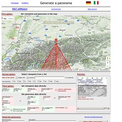
As a consequence, sometimes there result long times of waiting for the panoramas to appear. Very broad panoramas bind disproportionate resources. Therefore I have restricted the maximum width of the full panoramas to allow the fairest possible sharing of the limited resources. The restriction does not apply to the panoramas sent by e-mail. This restriction allows the creation of full 360-degree panoramas with zoom factor 2.
The application runs on a home computer with a quad processor and 4 MB memory, connected to the outside world with DSL 6000, i.e. outbound with max. 750 bits/s, on which my son also is playing FIFA11 and so on. So I ask you for your understanding that nothing will change without your contribution. Weather: Real-time Conditions. Files Available In This Category (Network Link for this category) Showing items 1 to 25 of 78<< 1 2 3 4 >>
Google Earth Flight Simulator Mod Tool. API Google Maps Earth Elevation Geocoding - Documentation Exemples et Tutoriels en Français - Tout savoir faire avec l'API Google Maps ... ou presque ! De nombreux exemples et tutoriels pour créer une carte, un marqueur, une info-bulle, calculer un itinér. Google Earth Plug-In - Télécharger. KML Builder for Windows XP, VISTA, Windows 7. Welcome.
Didacticiel Google Earth Actions publiques : Validation du code KML pendant son développement. Prerequisites No programming skills needed.
Familiarity with KML code will help, but advanced knowledge is not required. Install the software The first thing you'll need to do is install jEdit and the Java Runtime Environment that it relies on. You'll also need to download a file that we'll use later in the tutorial. Install the Java Runtime Environment (JRE): Go to and click Free Java Download. Google Earth. Cette page sert à chercher des cartes et vues satellites en ligne, grâce aux coordonnées géographiques fournies dans les articles de Wikipédia.
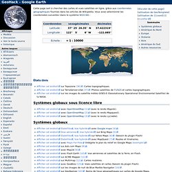
Vous avez sélectionné les coordonnées suivantes (dans le système WGS 84) : Systèmes globaux sous licence libre Systèmes globaux. Didacticiel Google Earth Actions publiques : Création de code KML à partir d'une feuille de calcul. Nous avons amélioré notre outil Spreadsheet Mapper ! GOOGLE EARTH. Google Earth / Google Maps. How to cover an IE windowed control (Select Box, ActiveX Object, etc.) with a DHTML layer. It was about 1 year ago that Coalesys released the first WebMenu 2.0 beta.
At that time we began demonstrating a technique for overlaying windowed controls in Internet Explorer. In case you don't already know, windowed controls in IE will always cover DHTML layers. That means if you have a DIV that pops up or floats on the page and it intersects with a windowed control (such as the common SELECT box), the windowed control will obscure the DIV, no matter what zIndex you have set for each element. More information is available in this Microsoft KB article. The initial solution adopted by most developers who cared about such things (including ourselves) was to dynamically hide windowed controls when it was necessary to display the DIV over them.
GE Layers - BFUHS Earth Science. Earth Actions publiques - Didacticiels. Using Google Earth. Utiliser l'API Google Maps : Sommaire. Que ce soit pour présenter des chemins de randonnées, situer des locations de vacances, ou pour préciser l’adresse d’un restaurant, rien de mieux qu’une carte, et ce, même sur Internet ! Cet article correspond au sommaire d’une série d’articles présentant les possibilités offertes par l’API de cartographie de Google Maps, vous permettant d’ajouter des cartes sur votre site, en offrant à vos utilisateurs la possibilité d’interagir avec celles-ci.
Ce sommaire sera mis à jour au fur et à mesure de l’ajout de nouveaux articles : 1 : Afficher une carte avec Google Maps : Les premiers éléments à mettre en place pour intégrer une carte à une page Web. 2 : Obtenir les latitude et longitude d’un point à partir de son adresse : Utiliser le service de Geocoding proposé par Google Maps, pour “traduire” une adresse en un couple latitude/longitude. 4: Marqueurs et fenêtres d’informations : Afficher des marqueurs et des fenêtres d’informations sur vos cartes.
Download Free SAS.Planet, SAS.Planet 100707 Download. Insérer un panoramique dans Google Earth. Didacticiel Google Earth Actions publiques : Utilisation efficace des liens réseau. Network links allow you to tell more complex and dynamic stories with your KML files. They allow you to do many more things, from keeping content updated to changing content in response to what the user does. You can learn about specifying network links in the KML Reference. This tutorial explains why network links can make your stories more compelling. Using KML as a Bookmark In the most generic sense, a KML file with a network link acts as a gateway into the content on your server.
In fact, many content owners choose to have users download a KML file that includes only a network link. Earth. Earth-autohotkey - Project Hosting on Google Code. This is a collection of tools for working with Google Earth, reading/modifying coordinates, converting between different coordinate formats, create ScreenOverlays and GroundOverlay image tiles, and geotag photos using Google Earth. Google Earth ScreenOverlay A small program for adding screen overlay images to Google Earth.
This is handy for adding legends and other images to Google Earth KML files, images that stay on a fixed spot on the screen as long as the KML is loaded. Téléchargé. We currently have 28,781 files which have been downloaded 28,062,059 times. Most Popular Files (currently) | Most Downloaded Files (all time) Newest Files | Top Rated | Unapproved Files | Top Submitters. Une chasse au trésor exceptionnelle sur Google Earth. Le 1er septembre 2011 va s’ouvrir une chasse au trésor inédite, ouverte aux internautes de douze pays : France, Belgique, Grande-Bretagne, Italie, Espagne, Finlande, Portugal, Pays Bas, Finlande, Etats-Unis, Canada et Brésil. Cette chasse sera ouverte durant sept mois, la clôture étant fixée au 31 mars 2012.
Le jeu va consister à résoudre un ensemble de quatorze énigmes dont les solutions forment un puzzle qui devra mener l’internaute à la position géographique précise où se trouve le trésor ! Ces énigmes pourront prendre la forme d’un visuel ou d’un texte à analyser. Chaque réponse sera visible via Google Earth, qu’il s’agisse de monuments, de formes ou de tracés visibles via des images satellites sur les cinq continents.
Les coordonnées Google Earth du trésor seront à enregistrer sur le sur le site officiel du jeu pour participer au grand tirage au sort qui désignera le vainqueur, qui recevra 50.000 euros. Site officiel du jeu (pas encore accessible) : www.jointhetreasurehunt.com. Catégories - Google Sightseeing Français. Google Earth Blog. Google Earth Voyager. Jsoft Anti-Spam Jsoft Anti-Spam est un logiciel qui, comme son nom l'indique, va filtrer le courrier indésirable avant que celui-ci n'atteigne votre boite email.
Il analyse pour cela les emails... 19 téléchargements.
Bloc Notes Earth. SAS PLANET.