
Mercator maps. Finaeus Map. Piri Reis map. Surviving fragment of the Piri Reis map showing Central and South America shores.
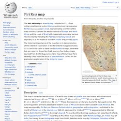
In his notes appended to it is written "the map of the western lands drawn by Columbus"[1] The Piri Reis map is a world map compiled in 1513 from military intelligence by the Ottoman admiral and cartographer Piri Reis (pronounced [piɾi ɾeis]). Approximately one-third of the map survives; it shows the western coasts of Europe and North Africa and the coast of Brazil with reasonable accuracy. Various Atlantic islands including the Azores and Canary Islands are depicted, as is the mythical island of Antillia and possibly Japan. The historical importance of the map lies in its demonstration of the extent of exploration of the New World by approximately 1510, and in its claim to have used Columbus's maps, otherwise lost, as a source.