
North Carolina's Fall Signature Attractions. Russell Brasstown Scenic Driving Tour. The Chattahoochee River's Headwaters (GA) Scenic wonders abound in this region of North Georgia.
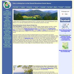
Venture into the Tray Mountain Wilderness, a 1,600 acre paradise for the whole family. Send your outdoorsmen to hunt the wild turkey, whitetail deer, quail, and even feral pigs that thrive in its rugged acres. Tramp down the paved path to Anna Ruby Falls and see where two creeks converge in the rare, 150-foot twin falls. Try to discover elusive Hidden Creek, which runs clear and cool for a day before it disappears. See the three tiers of Raven Cliff Falls, including its 100 foot cascade through a split in a solid rock outcropping. State parks like Unicoi, a rustic haven of cottages and campgrounds, and Vogel, with its blazing expanse of wildflower trails, are easily accessible from the Byway.
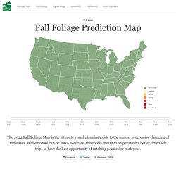
Roads Included in Byway SR 75 Alternate from SR 17 / 75, west to SR 348 348 from SR 75 Alt., northwest to SR 180 SR 180 from SR 348, east to SR 17 / 75 SR 180 Spur north from SR 180. North Carolina's Fall Signature Attractions. Peak Fall Foliage Map. Click on a state name to go to the Web site.Droughts will cause leaves to change a week or so earlier.

For a complete nationwide list: New England Peak Fall Foliage Forecast Map - Yankee Foliage - Your Source for New England Fall Foliage. Fall Foliage Map 2015 & Nationwide Peak Leaf Forecast. Why do leaves fall?
The beauty of nature is sometimes found in the profound ‘intelligence’ it exudes. Perennials, which includes trees, must protect itself in order to get through the harsh, freezing temperatures of winter. If trees did not shed their leaves, their soft vegetation would certainly freeze during winter time, damaging and no doubt killing the tree. In order to cope with the gruling winter temperatures, trees slowly close off the veins that carry water and nutrients to and from the leaves with a layer of new cells that form at the base of the leaf stem, protecting the limbs and body of the tree. Once the process of new cell creation is complete, water and nutrients no longer flow to and fro from the leaf - this enable the leaf to die and weaken at the stem, eventually falling gracefully to the ground. What happens to the fallen leaves? Earth, among other things, is fantastic at recycling. Asheville NC Fall Foliage Color Leaf Report 2015. Skip to main content Search form Fall Leaf Color Forecast, Asheville & NC Mountains The Asheville fall leaf color show in the North Carolina mountains attracts visitors from around the world.
With the 5,000-foot elevation change within 50 miles of Asheville, our lush Blue Ridge Mountain range puts on one of the longest-running autumn leaf color displays in the country. After enjoying nature's grand show, head to downtown Asheville to enjoy the many local restaurants and shops. Blue Ridge Parkway & Mountains Fall Leaf Color Forecast 2015 The number one question is: “When is the peak color?” Where to Find Color Week-by-Week. Fall Foliage Maps - weather.com. Fall Foliage Map : Travel Channel.com. Ready to start leaf peeping this fall?
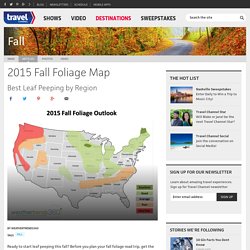
Before you plan your fall foliage road trip, get the peak predictions from weathertrends360. Check out the 14-day forecast and use the vacation planner tool for your next trip. For now, take a look at weathertrends360’s recommendations for the best regions to see autumn’s spectacular color show this year. Get inspired for fall and take a look at our list of fall foliage trips and Travel's Best Road Trips 2015. US Forest Service - Caring for the land and serving people. Home. Peak Fall Foliage Dates. Fall Foliage Drives. New England Fall Foliage Maps. Skip to main content Fall Foliage Maps The dramatic New England fall foliage starts in the northern New England states (Maine, Vermont, New Hampshire) typically in late September and moves down to the southern New England states (Connecticut, Massachusetts Rhode Island) around late October.
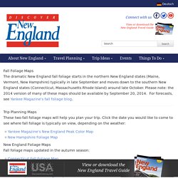
Please note: the 2014 version of many of these maps should be available by September 20, 2014. For forecasts, see Yankee Magazine's fall foliage blog. Trip Planning Maps These two fall foliage maps will help you plan your trip. Foliage.com - Maine's Official Fall Foliage Website. Greetings Visitors, Augusta, Maine (September 9, 2015) – Today is the official start of Maine’s fall foliage season and even though the weather resembles July’s, it is time to start planning for the upcoming fall season.
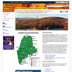
Currently, the 2015 Fall Foliage Report from the Maine Department of Agriculture, Conservation and Forestry states that there are only slight changes to view in the forests. "Right now we are expecting a typical fall foliage season with northern Maine (zones 6 and 7) reaching peak conditions the last week of September into the first week of October. The rest of the state’s progression of color will start occurring from north to south in mid-October. Coastal Maine typically reaches peak conditions mid-October through Oct. 24," according to Gale Ross, Maine’s fall foliage spokesperson.
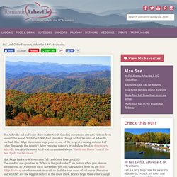
Plan Your Foliage Trip Resources below will help you plan where to go, shop, stay, and eat! State by State Guide to Fall Foliage. Fall Color Map for North Carolina. Conceived by Howard Neufeld and Michael Denslow Map Constructed by Michael Denslow This map above gives an estimation of the timing of fall color peaks for the various regions of North Carolina.
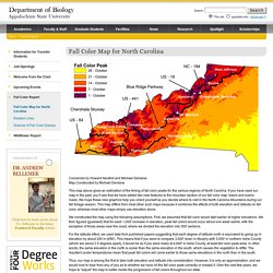
If you have used our map in the past, you’ll see that we have added two new features to the mountain section of our fall color map: towns and scenic roads. We hope these new graphics help you orient yourself as you decide where to visit in the North Carolina Mountains during our fall foliage season. This map differs from most other such maps because it combines the effects of both elevation and latitude on fall color, whereas most other maps simply use elevation alone. Peak Fall Foliage Map.