
Great Glen. Loch Ness. Loch Ness Loch Ness (/ˌlɒx ˈnɛs/; Scottish Gaelic: Loch Nis, [l̪ˠɔxˈniʃ]) is a large, deep, freshwater loch in the Scottish Highlands extending for approximately 37 km (23 mi) southwest of Inverness.
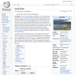
Its surface is 15.8 m (52 ft) above sea level. Loch Ness. Loch Oich. Loch Oich (Scottish Gaelic: Loch Omhaich) is a freshwater loch in the Highlands of Scotland which forms part of the Caledonian Canal, of which it is the highest point.[1] This narrow loch lies between Loch Ness (to the Northeast) and Loch Lochy (to the Southwest) in the Great Glen.[2] It is fed by the River Garry (from Loch Garry) from the West, and feeds the River Oich from its North end.
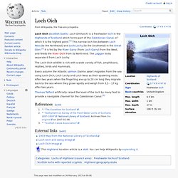
The Laggan locks separate it from Loch Lochy. The Loch Oich wildlife is rich with a wide variety of fish, amphibians, reptiles, birds and mammals. Every autumn the Atlantic salmon (Salmo salar) migrates from the sea using Loch Oich, Loch Lochy and Loch Ness as their spawning nests. After two years when the fingerling are up to 20 cm long they migrate back to the sea where they grow rapidly and weigh from 3,5 – 17 kg after two years. Loch Lochy. Geography[edit] Located 16 km (10 mi) southwest of Loch Ness along the Great Glen, the loch is over 15 km (9 mi) long with an average width of about 1 km (0.6 mi).
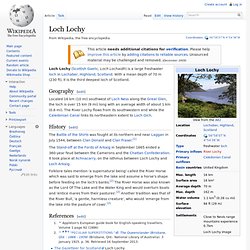
The River Lochy flows from its southwestern end while the Caledonian Canal links its northeastern extent to Loch Oich. History[edit] The Battle of the Shirts was fought at its northern end near Laggan in July 1544, between Clan Donald and Clan Fraser.[1] The Stand-off at the Fords of Arkaig in September 1665 ended a 360-year feud between the Camerons and the Chattan Confederation. Folklore tales mention 'a supernatural being' called the River Horse which was said to emerge from the lake and assume a horse's shape before feeding on the loch's banks.[2] The River Horse was also known as the Lord Of The Lake and the Water King and would overturn boats and 'entice mares from their pastures'.[2] Another tradition was that of the River Bull, 'a gentle, harmless creature', who would 'emerge from the lake into the pasture of cows'.[2]
Caledonian Canal. The Caledonian Canal is a canal in Scotland that connects the Scottish east coast at Inverness with the west coast at Corpach near Fort William.
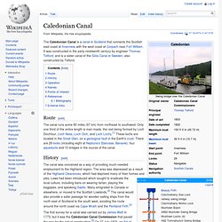
It was constructed in the early nineteenth century by engineer Thomas Telford, and is a sister canal of the Göta Canal in Sweden, also constructed by Telford. Route[edit] History[edit] The canal was conceived as a way of providing much-needed employment to the Highland region. The area was depressed as a result of the Highland Clearances, which had deprived many of their homes and jobs.
The first survey for a canal was carried out by James Watt in 1773, but it was the Caledonian Canal Commission that paved the way for the actual construction.[2] On 27 July 1803, an Act of Parliament was passed to authorise the project,[4] and the canal engineer Thomas Telford was asked to survey, design and build the waterway. Operation[edit] The canal is now a Scheduled Ancient Monument, and attracts over half a million visitors each year.
Names[edit] Cameron, A. Caledonian Canal. Loch Linnhe. Loch Linnhe Loch Linnhe (/lɒx ˈlɪni/ is a sea loch on the west coast of Scotland.
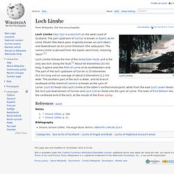
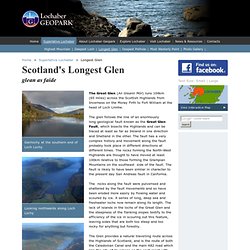
The part upstream of Corran is known in Gaelic as An Linne Dhubh (the black pool, originally known as Loch Abar), and downstream as An Linne Sheileach (the salty pool). The name Linnhe is derived from the Gaelic word linne, meaning "pool".[1] Notes Bibliography Coordinates: Overview of Great Glen. The Great Glen, Scotland's Longest Glen. Home > Superlative Lochaber > Longest Glen Gairlochy at the southern end of Loch Lochy Looking northwards along Loch Lochy Invergarry - looking northwards along Loch Oich.
Greatglenway.org. Great Glen Way - Official Website. Great Glen Way. An Gleann Mòr (The Great Glen) Great Glen Paddle. Learning Zone Class Clips - Investigating the Great Glen Fault in Scotland - Geography Video.