
Accueil - DONIA. Parcs nationaux de France site officiel. Vous êtes dans : Accueil > Accès direct > Actualités > Parc national de Port-Cros : protéger la posidonie grâce à une application pour smartphone Les gardes moniteurs du PNPC viennent de recevoir une formation à l'utilisation de l'application gratuite Donia récemment développée.
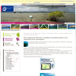
La posidonie, espèce protégée des côtes méditerranéenne, est victime des ancres marines des plaisanciers qui mouillent chaque année en Méditerranée. Grâce à cette application, les plaisanciers sauront s'ils peuvent jeter l'ancre ou pas. Très simple d'utilisation, elle géolocalise le marin sur sa tablette et lui signale s'il peut jeter l'ancre dans endommager l'herbier de posidonie : l'icône du bateau est verte quand il n'y a pas de risque ou rouge.Dès cet été, les gardes-moniteurs du Parc national de Port-Cros seront équipés de tablettes munies de cette application utilisable sur l'ensemble des côtes méditerranéennes.
Stay.com Social City Guides. Travellerspoint Travel Community. Bringing bike directions to more of Europe. Back in 2012, we added biking directions to our maps for a number of countries in Europe.
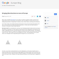
It proved to be a popular feature among cycling amateurs and enthusiasts. We're now delighted to announce that we are now enabling biking directions in Google Maps for Germany, France, Poland, Ireland, Luxembourg and Liechtenstein. Like in other countries, we've added information about bike trails, lanes and recommended roads directly to the map. In some countries we’ve worked with partner organisations. In others users have added hundreds of kilometers of biking paths through Google Mapmaker.
How does it work? Of course, you can also use biking directions for a more challenging trip. Regardless of the scope of your trip, roads and paths suitable for a bicycle are available by switching on the biking directions legend. One group of people who know where the best cycle paths are cyclists themselves! Calcul d'itinéraires : Jogging, Running, Course à pied, Vélo, Cyclisme, Roller, Randonnée - Tracez votre itinéraire sur la carte Google Maps - Entrainement de course à pied - Parcours de randonnée - Circuit à vélo.
Cartes géographiques gratuites, cartes muettes gratuites, cartes vierges gratuites, fonds de cartes gratuits. IGN, carte de randonnée, carte routière, guide de voyage, guide touristique, topo guide ffrp. Géoportail. China Media Map. Map data ©2014 AutoNavi, Google, SK planet, ZENRIN Terms of Use 200 km Journalism and Media Studies Centre (HKU) Welcome to the CMP's China Media Map What can you do with this map?
Contact Us David Bandurski <dbandursk@hkucc.hku.hk> Cédric Sam <cedsam@hku.hk> | Dev Blog Qian Gang 钱钢 The China Media Map is produced by the China Media Project at the University of Hong Kong's Journalism and Media Studies Centre Explore Chinese media with the CMP's new geographic information platform The China Media Map is a vision in progress.
The tool is based at present on data provided publicly by China's General Administration of Press and Publications (GAPP), the government agency that oversees all print media. After mapping GAPP data on the Google Maps platform, we enabled users to to navigate to various media by clicking on cities or regions and specifying a radius (1, 10 or 50 km). We will continue to curate and add to the GAPP data, providing more URLs and ensuring existing ones are accurate. La France vue du ciel / Survol de France : Photos aériennes de France. Webcam du monde. Le portail des territoires et des citoyens. Join the movement. Strategy and vision development. We help Local Authorities and transport bodies to develop strategy and vision for the delivery of ambitious but achievable cycling, walking and sustainable travel change.
We have over 30 years experience in delivering walking and cycling infrastructure and travel behaviour change projects. Together with a specialist research and monitoring unit dedicated to understanding all aspects of sustainable travel behaviour, we are well place to help you develop meaningful strategies that focus effort and justify investment. To discuss how we can help you, contact Jane Coles, telephone: 0117 915 0242 or email jane.coles@sustrans.org.uk We offer a wide range of services including: Mapping the potential for change A detailed understanding of the potential for travel behaviour change is essential to delivery of effective programmes and value for money.
Cycling strategy development Developing the business case Developing and supporting leadership Stakeholder engagement. Itinéraires et points d'intérêt GPS du Monde. Publiez et partager vos traces GPS. Le 1er site de recherche et de téléchargement d'itinéraires de qualité. Carte des Traces GPS de randonnee. Vos randonnees a la trace avec GPX-View.com. Comprendre l’étrange découpage des fuseaux horaires en 5 minutes.