
Compare the Size of Countries and States With These Map Mash-ups. This morning through Google Maps Mania I found a neat little site called MapFight.
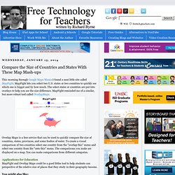
MapFight lets you select two U.S. states or two countries to quickly see which one is bigger and by how much. The select states or countries are put into overlays to help you see the size difference. MapFight reminded me of a similar, but more robust tool called OverlapMaps. Overlap Maps is a free service that can be used to quickly compare the size of countries, states, provinces, and some bodies of water. To create a visual comparison of two countries select one country from the "overlap this" menu and select one country from the "onto this" menu.
Applications for Education MapFight and Overlap Maps could be a good littles tool to help students can perspective of the relative size of places that they study in their geography lessons. Wonderville - Science and Tech Games for Kids. Wonderville is a great website for kids developed by the Science Alberta Foundation.
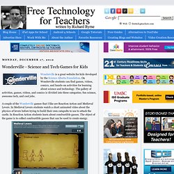
On Wonderville students can find games, videos, comics, and hands-on activities for learning about science and technology. The gallery of activities, games, videos, and comics is divided into three categories; fun science, awesome tech, and cool jobs. A couple of the Wonderville games that I like are Reaction Action and Medieval Levers. In Medieval Levers students watch a short animated video about the physics of levers before trying to build their own catapults to use to attack the castle. In Reaction Action students learn about combustible gasses. Applications for EducationWonderville's games, comics, and videos can be used by elementary and middle school students on their own. Watch an Illustrated Video of Howard Zinn’s “What the Classroom Didn’t Teach Me About the American Empire”
“Throughout U.S. history, our military has been used not for moral purposes but to expand economic, political, and military power,” says a cartoon Howard Zinn in Mike Konopacki’s 273-page comic book A People’s History of American Empire.
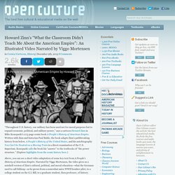
Written with Zinn and historian Paul Buhle, the book adapts Zinn’s pathbreaking history from below, A People’s History of the United States, and his autobiography You Can’t be Neutral on a Moving Train in a direct examination of the U.S. Imperium. Konopacki calls the book his “answer” to the textbooks of “the power structure.” (Explore highlights from the comic history here.)
Above, you can see a short video adaptation of some key text from A People’s History of American Empire. Along the way he notices that the map in every textbook labeled “Western Expansion” shows “the march across the continent as a natural, almost biological phenomenon”: Zinn goes on to chart the rise of U.S. But what of the war Zinn begins with, the war in which he fought? Beyond the Book: Infographics of Students' Reading History. A high schooler's reading history infographic.
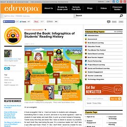
Photo credit: Sarah Mulhern Gross I'm an evangelist. A book evangelist, that is. I hand out books to students and colleagues, booktalking them in class, at lunch, and even in my email signature. I want my students to read widely and read often, to pick up a book instead of browsing Tumblr every time they are bored. Recently, I've also been fascinated by the way the human mind interprets visual symbols. When I found this lesson about reading histories, I was inspired. Getting Started I began by having the students brainstorm a list of books they've read. The next day, we began to explore some online tools for creating infographics. In pairs, students experimented with the tools by creating sample infographics based on data pulled from an article in that day's newspaper.
Reading History Infographic The next day, we started to work on our own infographics. The Bill of Rights in 30 Seconds and a Video Assignment for History Students. I've said it before and I'll continue to say to it, U.S.

Maps That Will Change the Way You See the World. Where Google Street View is available.
The supercontinent of Pangaea with modern day borders. The pink represents countries that the British have invaded. Goddammit, Brittan! Countries that don't use metric. Goddammit, America! Life in the 13 Colonies - FREE American History Lesson Plans & Games for Kids. How to Use Google Maps Engine Lite - A Short Video Tutorial. 6 Free Online Resources for Primary Source Documents.
The Common Core Learning Standards describe the importance of teaching students how to comprehend informational text.
They are asked to read closely, make inferences, cite evidence, analyze arguments and interpret words and phrases as they are used in a text. Primary source documents are artifacts created by individuals during a particular period in history. This could be a letter, speech, photograph or journal entry. If you're looking to integrate social studies into your literacy block, try out one of these resources for primary source documents. American History for Kids - Middle School Social Studies. American History for Kids - Middle School Social Studies.