
Barcino 3D. Cartoteca digital: mapes i fotografies antigues de Catalunya i tot el món. ArchAtlas: dept archaeology, Univ Sheffield, UK. History and geography of europe: euratlas.net. Historical Maps Euratlas Periodis Historical Atlas of Europe History of Europe A sequence of 21 maps showing the European states as they were at the end of each century from 1 to 2000.
Aegean Area History. Herodotus timemap. Book 1, Ch. 1 This is the display of the inquiry of Herodotus of Halicarnassus, so that things done by man not be forgotten in time, and that great and marvelous deeds, some displayed by the Hellenes, some by the barbarians, not lose their glory, including among others what was the cause of their waging war on each other.The Persian learned men say that the Phoenicians were the cause of the dispute.
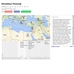
These (they say) came to our seas from the sea which is called Red, and having settled in the country which they still occupy, at once began to make long voyages. Among other places to which they carried Egyptian and Assyrian merchandise, they came to Argos,which was at that time preeminent in every way among the people of what is now called Hellas. Awmc - strabo map - ancient mediterranean world. X The Strabo Application is a georeferenced, interactive digital map of the Ancient Mediterranean World to accompany the text of the Geography translated by Duane W.
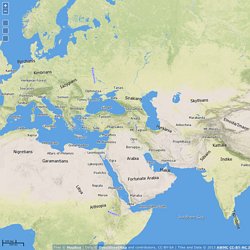
Roller and published by Cambridge University Press (2014). Awmc - ancient world mapping center. Keeping abreast of the ever-expanding set of resources relevant to the geography and mapping of the ancient world is a Herculean task and this page does not attempt to do that, rather it aims to provide a basic set of initial references for the community.
AWMC is always happy to consult with scholars and community members seeking to find certain, specialized resources. Print Resources Compendia W. Smith. 1854. Atlases W. Wall Maps R. Monographic and Edited Volumes O. Ancient Topography Athens J. Maison de l'Orient et de la Méditerranée. Le web est devenu une déclinaison évidente pour de nombreux projets scientifiques notamment ceux à caractère géographique.
La présentation et la diffusion des résultats s’en trouvent dès lors facilitées et élargies. Old maps online - univ of Portsmouth, UK and Klokan Tech, Switzerland. Pleiades.stoa.org. Pelagios. Digital atlas of the Roman Empire. OmnesViae: Roman Route Planner- Tabula Peutingeriana and Itinerarium Antonini.
Orbis: the Stanford Geospatial Network Model of the Roman World. Voie romaine. Un article de Wikipédia, l'encyclopédie libre.
Pour les articles homonymes, voir Voie. Liste de voies romaines. Un article de Wikipédia, l'encyclopédie libre.
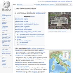
Cet article propose une Liste des voies romaines, classées par anciens ensembles géopolitiques de l'époque impériale : Voies romaines en Gaule[modifier | modifier le code] Voies romaines en Corse[modifier | modifier le code] Carte du monde - table de Peutinger. Tabula peutingeriana. Tabula Peutingeriana (section)—top to bottom: Dalmatian coast, Adriatic Sea, southern Italy, Sicily, African Mediterranean coast The Tabula Peutingeriana (Peutinger table, Peutinger Map) is an illustrated itinerarium (in effect, a road map) showing the cursus publicus, the road network in the Roman Empire.
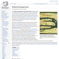
The original map (of which this is a unique copy) was last revised in the fourth or early fifth century.[1] It covers Europe, North Africa and parts of Asia (the Middle East, Persia, India). The map is named after Konrad Peutinger, a German 15–16th-century humanist and antiquarian. The tabula is thought to date from the fifth century.[2] It shows the city of Constantinople, founded in 328, yet it still shows Pompeii, not rebuilt after the eruption of Vesuvius in 79.
The prominence of Ravenna, seat of the Western Empire from 402, suggested a fifth-century revision to Levi and Levi. Map description[edit] Publication[edit] The Peutinger family kept the map until 1714, when it was sold. Table de Peutinger - légion VIII augusta. La Table de Peutinger, (Tabula Peutingeriana ou Peutingeriana Tabula Itineraria), connue aussi sous le nom de « Carte des étapes de Castorius » ou de « Table Théodosienne », est une copie réalisée vers 1265 par des moines de Colmar, d’une carte romaine réalisée vers 350, elle-même probablement la copie remise à jour d’une grande carte du monde peinte sur le portique d’Agrippa à Rome vers 12 de notre ère, où figurent les routes et les villes principales de l’Empire romain.
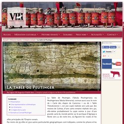
Pas moins de 555 villes et 3500 autres particularités géographiques sont indiquées, comme les phares et les sanctuaires importants, souvent illustrées d’une vignette. Présentation ^ C’est une longue bande de parchemin composée à l’origine de 12 parchemins mais il n’en reste aujourd’hui que 11 entreposés à Vienne (Autriche). Tabula peutingeriana, a roman road map. Paris, ville antique. Medieval Demographics Made Easy. Fantasy worlds come in many varieties, from the "hard core" medieval-simulation school to the more fanciful realms of high fantasy, with alabaster castles and jeweled gardens in the place of the more traditional muddy squalor.
Despite their differences, these share a vital common element: ordinary people. Most realms of fantasy, no matter how baroque or magical, can not get by without a supply of ordinary farmers, merchants, quarreling princes and palace guards. Clustered into villages and crowding the cities, they provide the human backdrop for adventure. Of course, doing the research necessary to find out how common a large city should be, or how many shoemakers can be found in a town, can take up time not all GMs have available. To the end of more satisfying world design, I've prepared this article. This article is a distillation of broad possibilities drawn from a variety of historical reference points, focusing more on results than on the details that create them.
Population Spread.