
Teaching Orienteering Skills. GeoNet.
Mr. Lee - Layers of the Earth rap. Longitude and latitude. Latitude And Longitude Game. Latitude and Longitude. Latitude and longitude ppt type presentation. Latitude and Longitude - Map Skills - Geography - FREE powerpoints, Free Games & Interactives for Kids. The Prime Meridian. The Prime Meridian runs through Greenwich, England and is at 0° longitude.
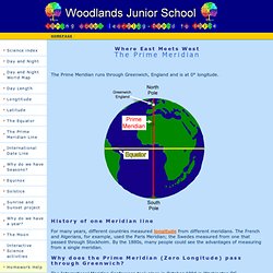
For many years, different countries measured longitude from different meridians. The French and Algerians, for example, used the Paris Meridian; the Swedes measured from one that passed through Stockholm. By the 1880s, many people could see the advantages of measuring from a single meridian. The International Meridian Conference took place in October 1884 in Washington DC. Twenty-five nations were represented at the conference by 41 delegates. The voting was 22:1 in favour of Greenwich (San Domingo, now the Dominican Republic, voted against); France and Brazil abstained. From Pole to Pole, the Prime Meridian covers a distance of 20,000 km. In the Northern Hemisphere, the Prime Meridian passes through the UK, France and Spain in Europe and Algeria, Mali, Burkina, Faso, Tongo and Ghana in Africa. The only landmass crossed by the Meridian in the Southern Hemisphere is Antarctica. Equator. Larry Ferlazzo, Teacher. MapZone - Homework Help - MapAbility - Compasses and directions
Latitude and Longitude Activity - Middle-High School. Latitude and Longitude Teaching State Standards While Exploring Central Asia A Geography Lesson for Middle & High School Classes Latitude and Longitude Activity Objective: Students will be able to use their knowledge of latitude and longitude to answer real-world questions using these concepts.

Standards: - WG.1.1Explain Earth’s grid system and locate places using degrees of latitude and longitude. - WG.2.1Name and locate the world’s continents, major bodies of water, major mountain ranges, major river systems, all countries and major cities. Approximate Length: 20 minutes Materials Needed: Copies of worksheets About the Lesson: This lesson is designed to help students learn longitude and latitude.
Procedures: 1. 2. 3. Note: Some questions, particularly the time zone one, may be removed for younger grades if the teacher feels these questions are too difficult for their class. *The map for the worksheet was created in February 2012 by the IAUNRC. [ Student worksheet starts here ] Mr. Young's Bouncy "A" - Map Skills Interactives & SmartBoard Lessons. MapZone - Homework Help - MapAbility - Compasses and directions World Map Match Game - Geography Games For Kids.
You will be shown 21 random countries each round of game play.
Your job is to place each nation in the correct location, as quickly as you can. Use your mouse to drag each country map to the correct location on the Earth. Try to remember the location of each country. The more you practice, the easier it will become to remember where each nation is located. How Fast Are You? Start With The Continents If this game is too difficult, have students begin by practicing on a specific continent. Parent's And Teacher's Note: The object of this game is to help students remember the locations of each country around the world.
Family Xpeditions: Orientometer. See You See Me - Landscapes - Map Skills. Mapmaker. Imagine that you are a mapmaker for the king and queen of Spain. You really want to sail across the sea to explore and chart the lands you would find there, but the king and queen value your service too much. They will not allow you to go. Many of your friends go. Some you never see again, but some come back with wonderful stories.
One day, one of your friends returns with a description of the place he visited. "I can't make a map of a place I've never seen! " Click here for your friend's description of the place he visited. After you finish your map, you can click here to see an artist's map from the same description. Click on a destination below to see maps by other students. The Search for Longitude.