
Trekking South-Baikal. Hiking Map Thanks to the TransSib, the south-eastern region of Lake Baikal is not only well developed but also quite densily populated.
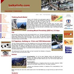
But right in its interior rises the Khamar Daban Mountain Range which will let you quickly forget civilisation. Lonesome valleys, mountain taiga, and peaks, higher than 2000 metres, invite for trips. You can see how the vegetation changes with the increase of altitude difference and watch the wildlife. Since the region is quite easy to reach by train or car you will have no difficulties to get to the different starting points of the trails. Climbing the Markovo Plateau. Hiking map 2-days trip with a difference in altitude of 1400 m For the challenging hike up to the Markovo Plateau and its highest peak you should schedule 2 days at least.
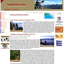
The first day you will climb the plateau up to a height of about 1600 m. The second stage takes you from the plateau to the peak and back down to the lake. The steep ascent from the shores of Lake Baikal up to 1877 m above sea level asks for a good condition and will reward mountaineers with a great view over the whole of the peninsula, Barguzin and Tshivyrkuy Bay (Barguzinskiy, Tshivyrkuysky Zaliv), and the close-by Ushkani Islands, where the world's one and only freshwater seal population can be found. 1st Stage from Glinka up the Plateau (12 km, 6 h) On the way to the Makarova cape photo: Lars Wagenknecht (approx. 13 km, 1100 m difference in altitude, 8 h hike) Glinka Cape Makarova End of Path Plateau Climbing Pik Markovo photo: Thomas Heidbüchel.
From Listvyanka in northern direction. Hiking Map 3 - 4 day tour, approx. 55km The hike from Listvyanka to Bolshoi Goloustnoe is one of the more popular ones and surely one of the most spectacular.
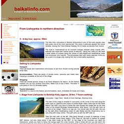
This route in particular appeals the transit traveller, running the Trans-Siberian Railway, for it's easily accessible from Irkutsk. The route is characterized by its constant changes between steep coastal cliffs, beaches and forest with various levels of difficulty. Taking this route you will meet a wide variety of scenery along the shores of Lake Baikal and breathtaking views from enormous rock massifs. Getting to Listvyanka: Transport: There are buses and marshrutkas (mini-buses) to and from Irkutsk running several times daily. Accommodation: There are plenty of private rooms, pensions and hotels here.
Shopping: There are several grocery shops to be found (Magazin) for basics. Lac Baïkal - Trek sur l'île d'Olkhone. Le départ très matinal d'irkoutsk nous a un peu secoué : bus de ligne très tassé au milieu des russes qui nous regardent de travers parce qu'on a 2 gros sac à dos encombrants, pour arriver à la gare routière et nous apercevoir que nous n'avons pas pris de billet pour nos bagages... oui car évidemment, ils voyagent avec nous et qu'en Russie il faut leur prendre une place...bref...nous voilà donc parti pour 6 heures de car avec, pour chauffeur, le sosie russe de Tex, sur une route completement défoncée par endroit, et ressemblant carrément à la rainbow road, à d'autres endroits.
Malgré tout, le trajet se passe sans encombres avec une pause dèj dans une tite yourte resto routier dans laquelle nous avons choisi (completement au hasard) ce qui s'est avéré être des beignets de légumes et un café. Le 2ième jour de trek commence sous un beau soleil avec une longue marche dans la steppe. La journée dura environ 20 km, puis nous installons la tente au bord d'une magnifique plage. Russie – Randonnée itinérante en boucle entre Khuzir et le sud de l’île d’Olkhon. Passionnés d’activités de plein air et confiants en notre expérience (plusieurs randonnées sur 3/4 jours de mon côté et le pote Toma compte à son actif le pèlerinage de St Jacques de Compostelle et pléthores de randonnées en Nouvelle-Zélande), nous ne pouvions nous rendre au lac Baïkal, sans y trouver le moyen de faire une randonnée itinérante de quelques jours.
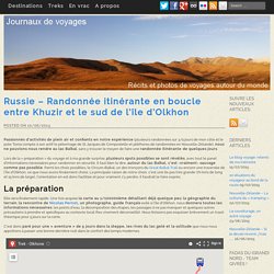
Lors de la « préparation » du voyage et à ma grande surprise, plusieurs spots possibles se sont révélés, avec tout le panel d’informations nécessaires pour randonner en sécurité. Il faut bien le dire, autour du lac Baïkal, c’est -vraiment- sauvage comme pas possible. Parmi les choix possibles, le Circum-Baïkal, un des tronçons du Great Baïkal Trail ou encore une traversée de l’île d’Olkhon, ce que nous avons finalement choisi. The Great Baikal Trail. Frolikha Adventure Costline Track (F.A.C.T.) Map The Frolikha Adventure Coastline Track (F.A.C.T.) leads you through one of the most beautiful, unspoiled and rugged scenery at Lake Baikal.
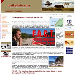
At the north shore, there are still no streets, no villages and apart from the sanatorium in Khakussy also no tourist infrastructure. Already at the arrival via Baikal-Amur-Magistrale (BAM) to Severobaikalsk, THE central starting point for all activities at the northern Baikal, you get an impression of the vast extent of Siberia and the loneliness of the taiga. Hikers on the F.A.C.T. should be aware of this situation and prepare themselves adequately in advance. First and foremost, good gear is essential, in particular sturdy shoes, food supply for up to ten days, an extensive first aid kit and especially experience of how to behave and orientate oneself in the wilderness!