
Discover Fascinating Vintage Maps From National Geographic's Archives. Cartography has been close to National Geographic’s heart from the beginning.
And over the magazine’s 130-year history, maps have been an integral part of its mission. Now, for the first time, National Geographic has compiled a digital archive of its entire editorial cartography collection — every map ever published in the magazine since the first issue in October 1888. The collection is brimming with more than 6,000 maps (and counting), and you’ll have a chance to see some of the highlights as the magazine’s cartographers explore the trove and share one of their favorite maps each day. Follow @NatGeoMaps on Twitter, Instagram, and Facebook to see what they discover. Discover Fascinating Vintage Maps From National Geographic's Archives. This Enormous 100-Year-Old Map of Rome is Still the City's Best. Vintage Maps of Mount Everest From National Geographic Archives. On this day, 65 years ago, Sir Edmund Hillary and Tenzing Norgay became the first people to reach the summit of Mount Everest.
Hillary described the moment to National Geographic the following year in the July 1954 issue: “We are there. Nothing above us, a world below.” Discover Fascinating Vintage Maps From National Geographic's Archives. Bizarre, Enormous 16th-Century Map Assembled for First Time. PUBLISHED December 7, 2017 This colorful and intricately detailed map from 1587 is more than nine feet by nine feet when fully assembled.
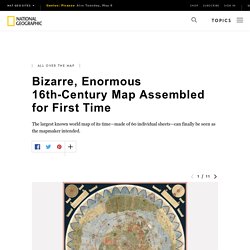
For the last 430 years, its 60 individual sheets were bound together as an atlas, but now they have finally been put together—digitally—to reveal a complete picture of the world as it was understood at the time. And what a world it was. The map is packed with fantastical creatures, from unicorns in Siberia to mermen frollicking in the Southern Ocean and a terrifying bird flying off with an elephant in its talons. The map reflects the geographical knowledge (and misconceptions) of its time, but in some ways it’s surprisingly advanced. 11 mapas con los que verás España de una manera diferente. Cuando hablamos de potencias mundiales estas suelen referir a países con un elevado poder en materia de política o economía.
Pero no siempre las naciones que suelen ser consideradas líderes mundiales lo son en todo o lo son siempre en aspectos positivos. Estos 11 mapas reflejan el mundo desde perspectivas muy diferentes. Clasificados por el número de armas presentes, el gasto energético o la baja por paternidad entre otros elementos, muchas de las grandes naciones no quedan tan bien paradas cuando se las contempla desde otros ángulos. En cuanto a España, nuestro país sale bien parado en relación a días de vacaciones anuales o gasto en cuidados médicos de sus ciudadanos, mientras que su posición puede sorprender en cuanto a número de presos o gasto energético.
Bizarre, Enormous 16th-Century Map Assembled for First Time. Interactive Maps. Interdisciplinary pre-release material May 2017. Map Projections. Map projections are used to represent the surface area of a solid object or a 3D object, and these map projections are used to create maps, and to make better visibility .
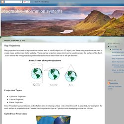
There are few projection types which can be used to project the surface of the Earth . but in almost like every projection portion of actual surface data will be lost or will get distorted . Types of Map Projections - Geolounge. The ways in which we visualize the world are varied- we have pictures, maps, globes, satellite imagery, hand drawn creations and more.
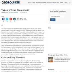
What kinds of things can we learn from the way we see the world around us? For centuries mankind has been making maps of the world around them, from their immediate area to the greater world as they understood it at the time. These maps depict everything from hunting grounds to religious beliefs and speculations of the broader, unexplored world around them. Maps have been made of the local waterways, trade routes, and the stars to help navigators on land and sea make their way to different locations. Where Google Street View is Available (Source: Google maps) Maps. Map of the Earth With Mercator Projection Using a Different Centerpoint (Source: imgur.com) Unfolding the Earth. #?borders=1~!MTY5NDM2MDc.MTk5MjYzMQ*NzQ2MDY0(NzQ2MDY0~!CONTIGUOUS_US*MTAwMjQwNzU.MjUwMjM1MTc(MTc1)MA~!IN*NTI2NDA1MQ.Nzg2MzQyMQ)MQ~!CN*OTkyMTY5Nw. Portolan Charts Intro - Bell Library: Maps and Mapmakers.
Where does that strange name come from?
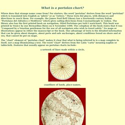
For starters, the word "portolan" derives from the word "portolani" which is translated into English as "pilots" or as "rutters. " These texts list places, with distances and directions to reach them. For example, the James Ford Bell Library has a fourteenth century Italian "Portolano del Adriatico e Mediterra" which gives sailing directions from Constantinople to Lisbon. The library also has the first printed book on navigation, titled Portolano per tutti I navichanti. This book was printed in Venice by one Bernardino Rizus on 6 November 1490. The "chart" element of "portolan chart" makes it clear that what is being referred to is a map complete in itself, not a map illuminating a text. A network of lines made within a circle, coastlines of lands, place-names, scales of distance, a compass showing cardinal directions, and indications of shoals, reefs, and islands along coastlines.
Mars. These Colorful Propaganda Maps Fueled 20th-Century Wars. Maps often have hidden agendas, conveyed through subtle choices made by the cartographer. That is not the case for these maps. The maps—which are currently in an exhibition called “War Map” at the Map House in London—have very clear messages. They’re war propaganda, meant to convince the public of an enemy’s evil tendencies, or that a conflict is winnable and worth the sacrifice.