
Perry-Castañeda Library Map Collection - UT Library Online. Wall Map Closet. California Geographical Survey Exploring the world, one map at a time...
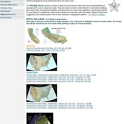
The Wall Map Closet contains a series of large format computer maps that may be downloaded and reproduced for use on classroom walls. They are meant to inform small children in instructional settings. As a result, they may lack some details commonly found on much more expensive commercial products. It is my intention to update the maps as time allows and instructors offer their ideas. CaliforniaCalifornia Population and Terrain Map - 28" x 36" pdf - 58.2 MBCalifornia Lifestyles 1990 - 19.25" x 29.5" pdf - 55 MB United StatesSample image - Conterminous United States - shaded relief - land cover - 18" x 10" - jpg - 4.3 MBConterminous United States - shaded relief - land cover - 60" x 35" - 72 dpi pdf - 14.7 MBConterminous United States - shaded relief - land cover - 60" x 35" - 144 dpi pdf - 47.1 MBConterminous United States - shaded relief - land cover - 60" x 35" - 300 dpi pdf - 86.1 MB © 2013 William Bowen Contact Me.
Free GIS Data - GIS Data Depot. Earth. ArchAtlas: The Origins of Farming in South-West Asia. The Origins of Farming in South-West Asia (Andrew Sherratt, 2005) Case Studies 2004-6 1) This sequence of maps illustrates a paper presented at the conference "New Perspectives on the Origins and Spread of Farming in Southwest Asia and Europe" in December 2003, sponsored by the AHRB.

A full written version of the paper will be found in the conference publication (see end). The maps and satellite images are provided here with an abbreviated commentary. 2) The complex of wheat, barley and legume cultivation (together with the keeping of domestic livestock), which originated in the Fertile Crescent of the Near East, emerged in the early Holocene and by 3500 BC extended from Ireland to Baluchistan. 3) What happened within this "nuclear area", and what geographical patterns lay behind the development of farming?
7) A SPOT image shows the relation of the tell to the cultivated oasis, now greatly extended by modern irrigation. 9) The preceding map, superimposed on a Landsat 5 (30m) image. GIS Download Data Server - Downloads. Downloads - Latest Homepage. GeoExpress is the industry-standard for creating, managing, accessing and distributing massive geospatial imagery such as aerial photos and satellite images without compromising image resolution or quality.

With the trial version of GeoExpress 9 you can use the entire suite of powerful image management tools within the 30-day evaluation period. You may purchase a full license for GeoExpress 9 through any GeoExpress Reseller. To find an authorized reseller in your area, please click here or contact LizardTech’s sales department at 1-866-725-5211 or geosales@lizardtech.com. Note: If you wish to upgrade to the full version of GeoExpress, do not download the trial version. Instead, please contact Sales in one of the ways noted above. Windows. Rocks And Dirt – Geology And Soil Maps Of The US And World. I love rocks.

I love dirt. And I love the maps that show them. A good geology map is visually like a weird hybrid between a Peter Max poster and Jackson Pollock drip painting, but also tells a story spanning several billion years of Earth’s history. I’ve found a few websites where you can find and download geology maps in a variety of formats. The National Geologic Map Database, run by the United States Geological Survey, catalogues maps and geologic names, and also describes what mapping is currently underway. Here’s a screenshot of an online geology map accessed through this website, just south of Barstow, California: For geology mapping of the US and the rest of the world, try the Interactive Mapping Tool at Cornell’s Geoscience Information System pages.
And when rocks die, they become dirt.