
Subglacial erosion - AntarcticGlaciers.org. What is subglacial erosion?
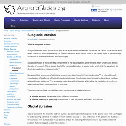
Subglacial erosion refers to processes that act at a glacier or ice sheet bed that cause the Earth’s surface to be worn down, broken up, and transported by ice. These processes leave behind some of the classic signs of glacial activity, in the form of erosional landforms and landscapes. Subglacial erosion is one of the key components of the glacial system, yet it remains poorly understood despite decades of research. This is largely due to the inaccessible nature of glacier beds, which limit the opportunity for direct observations or measurements1,2. Because of this, processes of subglacial erosion have been based on theoretical models3-6 or inferred through investigations of landforms left behind in deglaciated areas. These approaches have identified two main mechanisms of subglacial erosion: Mass balance. Glossary - Terms Glacier Types.
An introduction to Glacier Mass Balance. Glacier mass balance | Measuring mass balance | Mass balance gradients | Mass balance through time | Further reading | References | Comments |
Geo563 7.SubglErosion. 0495555061 137189. State of the Climate: Mass Balance of Mountain Glaciers in 2011. Alpine glaciers have long been recognized as sensitive indicators of climate: just as glaciers often shrink due to melting in summer and grow by accumulating new snow in winter, changes in their size over longer periods indicate a warming or cooling climate.
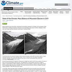
Annual measurements of a glacier’s thickness or length are used to tell if accumulation of snow or loss of ice has dominated over the year. The difference in accumulation and loss is called a glacier’s mass balance. When melting exceeds snow accumulation, a glacier loses mass. It thins, and its leading edge (terminus) retreats. The photos above show the retreat of Alaska’s McCall Glacier between 1958 (left) and 2003 (right). In the Alps, below-average winter snowfall and significantly above-average spring and summer temperatures resulted in negative mass balance in 2011. Nonetheless, data for 2010 (the most recent complete year available) indicate that worldwide, mountain glaciers lost more mass than they gained. Reference. Climate Change: Glacier Mass Balance. In Earth’s highest mountains and across the land in both polar regions, brief summers were long overpowered by snowy winters.
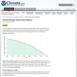
Over many centuries, layers of snow accumulated to form thick glaciers. Present since the last ice age, most of the world’s glaciers are now shrinking or disappearing altogether. Explore this interactive graph: Click and drag either axis to view different parts of the graph. To squeeze or stretch the graph in either direction, hold your Shift key down, then click and drag. The graph shows cumulative mass loss in "meters of water equivalent," which is the depth of the meltwater spread out over the glacier's surface area.
Measuring glacier change Glaciers gain mass through snowfall and lose mass through melting and sublimation (when water evaporates directly from solid ice). Glossary - Terms Glacier Types. Mass balance. Glacial erosion. Cairngorms. Cairngorms. During the Ice Age, or Pleistocene, (around 2.6 million years ago) glaciers covered large parts of the northern hemisphere.
During this time there were many long, cold periods (glacials), broken by shorter, warmer intervals (interglacials) when the climate was similar to that of the present day or slightly warmer. During the colder phases of the Ice Age, mountain glaciers and icefields formed repeatedly in the Highlands. When the climate was at its very coldest, much larger ice sheets covered the whole of Scotland. The landscape of the Cairngorms National Park has therefore been sculpted during the course of many glaciations. The last major glaciation in Scotland was at its height around 22,000 years ago. 22,000 years ago.
Throughout the last 11,500 years, rivers, frost and slope processes have continued to modify the shape of the land, albeit on a smaller scale. How do we know all this? National Snow and Ice Data Center. Kahiltna Glacier is a long mountain glacier, into which several tributary glaciers flow.
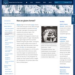
—Credit: Photographer unknown. 1942. Kahiltna Glacier: From the Glacier Photograph Collection. Boulder, Colorado USA: National Snow and Ice Data Center. Digital media. Glaciers begin to form when snow remains in the same area year-round, where enough snow accumulates to transform into ice. National Snow and Ice Data Center. Types of glacier. 1.
Bennett, M.R., 2003. Ice streams as the arteries of an ice sheet: their mechanics, stability and significance. Earth-Science Reviews, 2003. 61(3-4): p. 309-339. Types of Glaciers (and how they behave) - Extreme Ice Survey. Glacier and ice stream movement is complex.
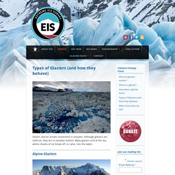
Although glaciers are solid ice, they are in constant motion. Many glaciers end at the sea, where chunks of ice break off, or calve, into the water. Alpine Glaciers Alpine glaciers, also called mountain glaciers, are found throughout the world’s high mountains. If a mountain glacier increases in size and begins to flow down the valley, it is then described as a valley glacier. Some, such as Alaska’s Columbia Glacier, are literally rivers of ice, flowing down mountains and carving valleys. Greenland and Antarctica.