
How Long Has Evolution Been Going On? Book Review: Global warming and oceans, a 21st century perspective. A new book summarizing much of what we know about oceans and the role they play in shaping our Earth's climate was just published.
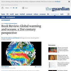
For researchers like myself, we often become fixated with learning the newest facts or reading the latest studies in our fields. Every so often, however, it is necessary to take a step back and provide a retrospective look at how our knowledge has developed with time. Such a retrospective was just provided by some of the world's most qualified oceanographers. It is an update to a legendary text that was first printed in 2001. This is the second edition of "Ocean Circulation and Climate – Observing and Modelling the Global Ocean" published in 2001 at the end of the World Ocean Circulation Experiment (WOCE). Since WOCE there has been enormous further progress both on ocean observations and modeling. The introduction provides a great justification for the text, Major cities will hit climate 'tipping point' by 2047, study shows.
Climate change is poised to usher in "a new normal" where average annual temperatures are concerned — and that normal is going to be a hot one.
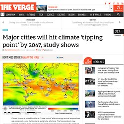
That's according to new research published in this week's Nature, which warns that regions around the world will soon see temperature increases that have no recorded historical precedent. "Go back in your life to think about the hottest, most traumatic event you have experienced," study author Camilo Mora told The New York Times. "What we're saying is that very soon, that event is going to become the norm. " Mora's team crunched data from climate models to come up with the findings, which are based on the premise that greenhouse gas emissions will continue unabated in the years to come. The data analyzed by his team comes from 39 different climate models out of 12 countries, most of which have already been used in other published research.
Unprecedented-shift-in-temperature-will-begin-to-hit-tropics-in-less-than-a-decade-8869608. Click image above to enlarge graphic Scientists discovered that the tropics, which are home to the highest densities of wildlife as well as some of the most vulnerable human populations on the planet, will be hit hardest and earliest by climate extremes.
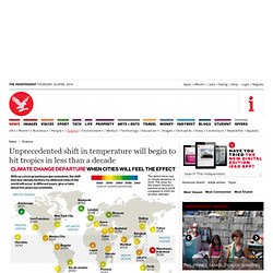
A “meta-analysis” of future climate predictions culled from 39 global computer models used in climate research found that tropical regions are expected to cross the threshold into unprecedented climate change significantly earlier than other areas of the world. If industrial emissions of greenhouse gases remain unchanged in a “business-as-usual” scenario then some tropical regions, such as Jamaica and Indonesia, could see a shift into new climate territory as early as the next decade, the scientists warned. “The results shocked us. Regardless of the scenario, changes will be coming sooner. “Scientists have repeatedly warned about climate change and its likely effects on biodiversity and people. “Extinctions are likely to result. NASA and NOAA turn the 'Blue Marble' green in breathtaking new satellite images. Scientists have released new satellite images that show how much of the Earth's surface is covered in vegetation.
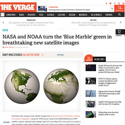
Using the VIIRS sensor aboard the NASA/NOAA Suomi NPP satellite, experts collected data between April 2012 and April 2013 and used it to create a new vegetation index which identifies how much of the sun's energy is absorbed by plant life on Earth and how much is reflected back into space. The resulting photos (a high-resolution interactive map can be found here) highlight areas where vegetation is lush and where it is barren — including deserts, snowy peaks, and urban areas — stripping out 75 percent of the planet covered with water.
Using infrared imaging, NOAA is able to distinguish between vegetation, rock, and other terrain more accurately than other satellites. This allows scientists to advance weather model accuracy and understand changes in seasonal vegetation cover. The Earth breathes, and it is beautiful.