
How Google Builds Its Maps—and What It Means for the Future of Everything - Alexis C. Madrigal. An exclusive look inside Ground Truth, the secretive program to build the world's best accurate maps.
Behind every Google Map, there is a much more complex map that's the key to your queries but hidden from your view. The deep map contains the logic of places: their no-left-turns and freeway on-ramps, speed limits and traffic conditions. This is the data that you're drawing from when you ask Google to navigate you from point A to point B -- and last week, Google showed me the internal map and demonstrated how it was built. It's the first time the company has let anyone watch how the project it calls GT, or "Ground Truth," actually works. Google opened up at a key moment in its evolution. And for good reason. "If you look at the offline world, the real world in which we live, that information is not entirely online," Manik Gupta, the senior product manager for Google Maps, told me. This is not just a theoretical concern.
But that would entail actually building a better map. Google "Opens The Kimono" On How It Builds Maps. The Atlantic published an article about what Google calls “Ground Truth,” its allegedly top-secret map-development process.
As the name implies, the idea is to create digital maps that more accurately reflect the ground truth of the real world vs competitors’ offerings. The trigger for the article is undoubtedly Google’s desire to expose the complexity, layers and (by implication) cost of the process of generating maps in the wake of its ouster from iOS 6 and increasing competition from Nokia/Navteq and OpenStreetMap. There are several things about the article and the revealed Google map-development process that are interesting. The first is that Google’s Street View process is likened to a webcrawler for the real world, along with the notion that it’s “indexing” the physical world just as Google indexes documents and pages online.
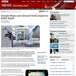
The article quotes Google Maps’ Brian McClendon on the use of Street View and the “OCR-ing” of the physical world: Google Maps uses Ground Truth project to battle Apple. 9 September 2012Last updated at 22:04 ET By Leo Kelion Technology reporter Google's software analyses Street View photographs to locate and identify relevant information which it then adds to its maps A new front opens up in the smartphone battle between Google and Apple this week when the search giant's mapping technology is dropped from iPhones and iPads' Maps app when they are upgraded to the latest version of the iOS operating system.
The move is a blow to Google: it is likely to impact advertising sales because it will not be able to show "sponsored links" on iOS's default maps, and it will stop receiving data about how people use the software. Until now Google has dominated mobile maps. Android and iOS jointly account for about 85% of global smartphone shipments and an even higher percentage of tablets according to research firm IDC. Handset owners who use GPS navigation in Google Maps can send back data to improve the service Ground Truth Continue reading the main story Ground Truth 1.0.