
Mapping South Africa with dot distribution. Five Boroughs: Building Age NYC. The Best Map Ever Made of America's Racial Segregation. Last year, a pair of researchers from Duke University published a report with a bold title: “The End of the Segregated Century.”
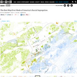
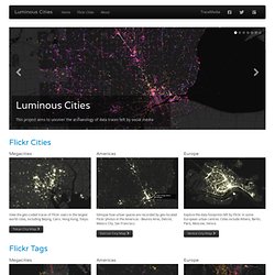
U.S. cities, the authors concluded, were less segregated in 2012 than they had been at any point since 1910. But less segregated does not necessarily mean integrated–something this incredible map makes clear in vivd color. The map, created by Dustin Cable at University of Virginia’s Weldon Cooper Center for Public Service, is stunningly comprehensive. Real-time local Twitter trends - Trendsmap. Twitterfall. TraceMedia - Luminous Cities. Megacities View the geo-coded traces of Flickr users in the largest world cities, including Beijing, Cairo, Hong Kong, Tokyo.
Tokyo City Map. Open Source GIS. The one million tweet map #onemilliontweetmap.