
Database of Georeferenced Geological Maps. Geoscientists Can Now Access Over 18,000 Maps From SEPM Through Elsevier's Geofacets. Geoscientists Can Now Access Over 18,000 Maps From SEPM Through Elsevier's Geofacets NEW YORK, September 17, 2012 — (PRNewswire) — Collaboration makes over 225,000 maps available on-demand to help geoscientists quickly and accurately assess the opportunities and risks involved in oil & gas exploration Elsevier, a world-leading provider of scientific, technical, and medical information products and services, and SEPM (Society for Sedimentary Geology) today announced the integration of more than 18,000 geological maps from SEPM into Elsevier's web-based research tool, Geofacets.

First announced in April 2012, and now available to Geofacets users, the integration grants geoscientists access to scientific information that can provide key insight into the potential of regions for oil and gas exploration, allowing geoscientists to make predictions and guide exploration with greater confidence. About SEPM (Society for Sedimentary Geology) About Geofacets About Elsevier. Map Collection. The Map Collection at Yale University Library. Collection History. Worldmapper: The world as you've never seen it before.
Old-Maps - the online repository of historic maps - home page. MAPCO : Map And Plan Collection Online. Map Collections Home Page. Map Collection - World Sites Atlas. World Atlas A physical and a political map of the world, divided into tiles for easy navigation.
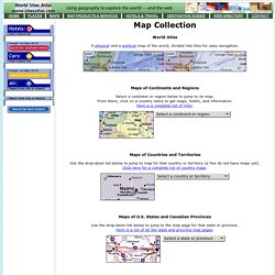
Maps of Continents and Regions Select a continent or region below to jump to its map. From there, click on a country name to get maps, hotels, and information.Here is a complete list of links. Old Maps Online. Antique Maps, Old maps, Vintage Maps, Antique Atlases, Old Atlases. Maps. David Rumsey Historical Map Collection. The 15 Maps That Explain The World In 2012. The Top 10 Best Maps — Ever! « Geo-Web Junction.
December 27, 2011 By: Tom Koehler There is one thing I look forward to at the end of the year that has absolutely nothing to do with the holiday season.

In fact, it helps to keep me sane by taking my mind off of the holiday shopping madness and dreadfully frigid weather. I’m talking about all these “Best of 2011” lists you see popping up in every magazine and corner of the Internet. It’s a bit of a guilty pleasure of mine, but when I come across one of these lists I can’t help but browse through them, and inevitably get angry when I disagree with who or what they put at the top. Well I think it’s about time for me to try my hand at one of these lists. 10. (source: The Waterman Projection has got to be the prettiest projection at the dance. 9. When asked how big their country is, most schoolchildren in America go ahead and assume their country is much larger than it actually is. 8.
Historical maps are always interesting. 7. 6. 5. 4. 3. 2. (Source: FloatingSheep - On, Wisconsin! World Maps. Library of Congress Maps Collections. The Library of Congress Search by Keyword | Browse by Geographic Location Index | Subject Index | Creator Index | Title Index The Geography and Map Division of the Library of Congress holds more than 4.5 million items, of which Map Collections represents only a small fraction, those that have been converted to digital form.

The focus of Map Collections is Americana and Cartographic Treasures of the Library of Congress. These images were created from maps and atlases and, in general, are restricted to items that are not covered by copyright protection. Map Collections is organized according to seven major categories. The Collection. MapMart Cloud Rolls onto the GIS Scene. LONE TREE, COLORADO, January 9, 2012 – With the arrival of the New Year comes the formal release of the MapMart Cloud from MapMart.

MapMart has long been the one-stop shop for traditional geospatial data and imagery acquisition and will remain so. The MapMart Cloud will complement MapMart by offering the same high quality and highly accurate data for consumption via high speed data stream. MapMart Cloud offers hundreds of web services of data sets for the U.S. and the world. “Going to the Cloud is the distinct and immovable trend in geospatial data usage,” said Mike Platt, President and CEO of MapMart.
“GIS users have had to deal with downloading and storing ever-growing data sets for too long. Map Collection Digital Maps. The Harvard Map Collection is one of the oldest and largest collections of cartographic materials in the United States with over 500,000 items.
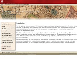
Resources range from 16th century globes to modern maps and geographic information systems (GIS) layers. A selection of our materials has been digitally imaged and is offered both as true picture images and georeferenced copies. This Virtual Collection includes those maps and atlases that are available through the Harvard Image Delivery Service. Those maps that have been georeferenced are available through the Harvard Geospatial Library. Maps of all kinds. 4 New Typographic Maps. HapMap. Wind Map. An invisible, ancient source of energy surrounds us—energy that powered the first explorations of the world, and that may be a key to the future.
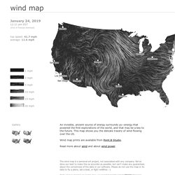
This map shows you the delicate tracery of wind flowing over the US. The wind map is a personal art project, not associated with any company. We've done our best to make this as accurate as possible, but can't make any guarantees about the correctness of the data or our software. Please do not use the map or its data to fly a plane, sail a boat, or fight wildfires :-)