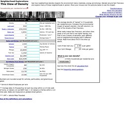

SmartGrowth Home Page. P&zhandbook. Db9. This View of Density : SFLCV. The average density of "sprawl" is 3 households per residential acre.

Compare the environmental impact of sprawl's density ( the left columnn ) to that of the streets of San Francisco. What really makes San Francisco, and other cities great is not just that it has higher denisty, but that it has a variety of densities, each different kind of neighborhood bringing with it different things.
Read more about this in the links up above. See how this what this all calculated from See the frequently asked questions 467-536 households per residential acre West of Union Square in San Francisco; 3 x 4 block zone has: 7 live theatres, fine hotels, cafes and markets; Buildings of 1 to 36 stories, mostly 4 - 16 stories; 15% of land residential; limited parking; Change your mileage & gas cost. Residential Acre. This calculator has been developed for densities ranging from sprawl, 3 hh/res ac, to 500. Concrete or asphalt in roads and sidewalks.
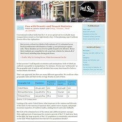
Water Used. Calculations. Shopping Opportunities. Ped Shed » Fun with Density and Transit Statistics. Conventional wisdom holds that the U.S. is too spread out for workable mass transportation except in a few high-density cities.

Urban planning expert Anthony Downs offers this explanation: But in 2000, at least two thirds of all residents of U.S. urbanized areas lived in settlements with densities of under 4,000 persons per square mile. Those densities are too low for public transit to be effective. Hence their residents are compelled to rely on private vehicles for almost all of their travel, including trips during peak hours.– Traffic: Why It’s Getting Worse, What Government Can Do Is that accurate? That’s one approach, but there are many different approaches. Source: U.S. Looking at the entire United States, what impresses is the vastness and diversity of the land. But look at the urbanized area of the nation and a different picture emerges. Sixty-eight percent of Americans live at an average density of 2,670 persons per square mile. 12basicguidelines. Data Center and Library : Economic and Business Research Center : Eller College of Management : The University of Arizona.
BOS memo on Urban. February 24, 1998 Memorandum Report to Pima County Board of Supervisors on Urban Growth and Development in Eastern Pima County Introduction The Board will, at the study session of February 24, 1998, discuss Urban Growth issues in Eastern Pima County.

The attached report is intended to provide the Board with a historical perspective of regional land use planning in Pima County, some of the tools and actions being used by other communities in growth management, and to provide a framework for future Board policy study and direction. Comprehensive Planning Much of the work and study to develop a desirable land use plan for eastern Pima County has been completed through years of public study and debate. Planning and Implementation Contradictions All adopted planning documents recognize the importance of the higher urban density and mixed uses (jobs and shopping near home) to develop a more compact urban form.
Fragmented Land Use Decision Making Recommendations 2) Strengthen the Urban/Rural Boundary. Visualizing_Density. Translating_a_Regional_Vision_into_Action. Aces-workingpaper1. DL-TaskCandD_001. Solutions-en.pdf - Powered by Google Docs. Jargonfactsheet.