
HamJay32. Des cartes pour évaluer les temps de déplacement. La distance seule ne permet pas d'estimer le temps nécessaire pour se rendre d'un point à un autre.
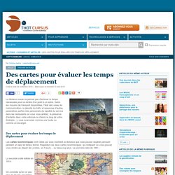
Selon les moyens de transport disponibles, l'état des voies de communication, la densité du trafic et beaucoup d'autres paramètres parfois très personnels (la rapidité du service dans les restaurants où vous vous arrêtez, la présence d'enfants dans votre véhicule ou d'amis le long de votre itinéraire...), vous avancerez comme une fusée ou comme un escargot. Des cartes pour évaluer les temps de déplacement Les cartes isochroniques sont celles qui vous montrent la distance que vous pouvez espérer parcourir pendant un laps de temps donné. Regardez ces deux cartes isochroniques, qui indiquent où vous pouvez vous rendre au départ de Londres, en 5 jours... ou beaucoup plus. La première date de 1881 La seconde a été éditée en 1914 : On constate qu'en un peu plus de 30 ans, les temps de voyage n'ont pas radicalement changé. L'open date au service des voyageurs Références : Mapnificent - Dynamic Public Transport Travel Time Maps.
Warranties There are no warranties.
The underlying data is generated automatically and the service is based on heuristics. Do not rely on this service. The user agrees that the service is provided "as is" and "as available" without any warranty of any kind, express or implied, including, without limitation, the implied warranties of merchantability, fitness for a particular purpose, accuracy and noninfringement. The site's owner does not warrant that the service will be available at any given time, secure, accurate, or free of errors. The user shall indemnify, defend, and hold harmless the site's owner and the site's public transport data providers from and against all fines, suits, proceedings, claims, causes of action, demands, or liabilities of any kind or of any nature arising out of or in connection with the use of this service or this agreement.
Copyrights The data that this service is using is protected under copyright law. Digital Geography. 20.
July 2015 agol arcgis online cartoDB comparison CSV easy mangomap Mapbox simplemappr webmaps Working with a desktop GIS might be a good choice for geodata-experts, GIS-people in general and everyone who is inside the fields of geosciences. If you don’t want to struggle with a desktop mapping software or you “just want to create a map” for your publication, business data, website or professional service the following online mapping solutions might be the one-stop-shop for your needs. Shortlinks to results: Prior our short “overview” let’s explain the setting.
The “crucial” part: We only have a csv file with city names and attributes (incl. coordinates) and a kmz from Google Earth where we “digitized” provinces. We will try to export the map as an image and try to embed into our blog post as an interactive map. Web Mapping Made Easy — Heron MC v1.0.5. Introduction — OpenGeo Suite 4.6.1 User Manual. PgRouting Workshop Manual — Travaux pratiques - Routage FOSS4G avec les outils de pgRouting, le reseau routier d'OpenStreetMap et GeoExt.
Geomajas. Labs EasyBlog.It - Web Mapping Applications. Edit fiddle. Jquery - Click link inside Leaflet Popup and do Javascript. Leaflet Map with Customized Popup. CartoWeb - Home. Quickstart — MapFish v2.2 documentation. Generating the base Use: (env) $ paster create -t mapfish MapFishApp MapFishApp is the name of the MapFish application you’re creating, you can pick any name of your choice.
We’ll assume that you choose MapFishApp in the rest of this quickstart. When asked what template engine to use answer mako, which is the default. You should now have a folder named MapFishApp. Now check that your MapFish application works. (env) $ cd MapFishApp (env) $ paster serve development.ini This command starts your application in the Paster web server, which is a pure-Python web server commonly used during development. Open in your web browser, you should get the default page: Installing the JavaScript toolbox You are now going to install the MapFish JavaScript toolbox in your application.
Installing the JavaScript toolbox is done by applying the mapfish_client template. Warning. Quickstart — MapFish v2.2 documentation.