
MceWeather shows your present local weather and a forecast for the next days on your Media Center. MceWeather shows weather for your region on your TV or PC.

The plugin provides data from all over the world (many locations can be shown, please just try if your next larger city can be found by the program). It shows the forecast for the next days and also shows you a satellite image of your country. All weather data is provided by wetter.com. The current weather conditions are shown with some interesting additional information. Let the forecast show you, what the weather will be like the next days. The look can be changed with themes to some other color-variations, like red for example. The overview page shows the current weather and the forecast for the next days on one single page. The plugin has many built-in satellite-images to choose from.
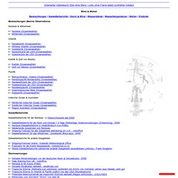
There are several satellite-images choosable in the program, although we have not found images from all over the world. The language of the plugin can be chosen from different languages. Wassertemperaturen. Karibik: Aktuelle Wassertemperaturen in der Karibik. Seewetter - Das aktuelle Wetter auf den Meeren. [Startseite][Gästebuch][Site ohne Menü / Links ohne Frame laden] [Linkfehler melden] Wind & Wellen Beobachtungen | Seewetterberichte | Sturm & Wind | Wasserstände | Wassertemperaturen | Wellen | Eisfelder Beobachtungen (Marine Observations) Nordsee & Mittelmeer / Nordsee (Oceanweather) / Mittelmeer (Oceanweather) Atlantik / Nordatlantik (Oceanweather) / Mittlerer Atlantik (Oceanweather) / Südatlantik (Oceanweather) / Nordostküste der USA (Oceanweather) / Südostküste der USA (Oceanweather) Karibik & Golf von Mexiko / Karibik (Oceanweather) / Golf von Mexiko (Oceanweather) Pazifik / Bering-Strasse / Alaska (Oceanweather) / Nordostpazifik-Nordamerika (Oceanweather)

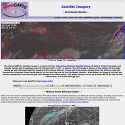
Inc: Current Marine Data: Global Waves. Marine Weather. Tropical Weather. Hurricane Sector - Satellite Imagery. - - click on image for animation - - - - Waves from African Coast - - Below the most recent combined Meteosat-SSM/I MPE (Multi-sensor Precipitation Estimate) and Meteosat Airmass product, focussing on any waves coming off the African coasts.

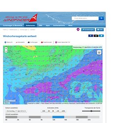
These waves have the potential to develop into hurricanes. Updated every 30 minutes (MPE) or 60 minutes (Airmass). More information on these products on the EUMETSAT Website. . - - Saharan Air Layer (SAL) - - The Saharan Air Layer (in red below) is a very dry air-mass coming from the African continent. Swellfinder - Wellenhöhe, Wellenrichtung Vorhersage Atlantikküste USA & Canada. Beschreibung Dies ist die Wind-, Wellen- und Wettervorhersage-Karte für weltweit.

Windfinder ist spezialisiert auf Messwerte und Vorhersagen für Wind, Wellen, Tiden und Wetter für windbezogene Sportarten wie Kitesurfen, Windsurfen, Surfen, Segeln oder Paragliden. Auf der Windvorhersage-Karte für weltweit ist die vorhergesagte Windrichtung mittels Pfeilen angegeben, die vorhergesagte Windstärke ist mit Farben angegeben. Die Pfeile zeigen in die Richtung in die der Wind weht. Die Vorhersage basiert auf dem GFS Modell. Verwende das Animations-Feld unterhalb der Wind- und Wettervorhersage-Karte für weltweit, um die Vorhersagen für die nächsten 7 Tage zu sehen. Einheiten Unsere Standard-Einheiten sind Knoten und Grad Celsius.
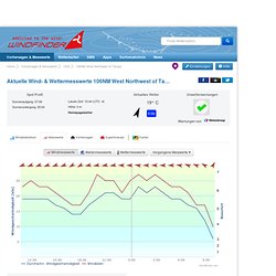
Hilfe Wenn du mehr Informationen über die Windvorhersage-Karte für weltweit benötigst, benutze unsere Hilfe-Seite. Wind- & Wettermesswerte in Echtzeit 106NM West Northwest of Tampa. Beschreibung Dies sind die Wind-, Wellen- und Wettermesswerte für 106NM West Northwest of Tampa in Florida, USA.

Windfinder ist spezialisiert auf Messwerte und Vorhersagen für Wind, Wellen, Tiden und Wetter für windbezogene Sportarten wie Kitesurfen, Windsurfen, Surfen, Segeln oder Paragliden. Dies sind die aktuellen Messwerte der Wetterstation in 106NM West Northwest of Tampa. Die Linien in der Grafik geben die durchschnittliche Windgeschwindigkeit und die Windböen an, die Pfeile geben die Windrichtung an. Die Pfeile zeigen in die Richtung in die der Wind weht. Benutze die Windmesswerte für 106NM West Northwest of Tampa um die besten Last-Minute-Reiseziele für deinen Kiteboarding-, Windsurfing oder Segel-Urlaub in USA zu finden. Einheiten Unsere Standard-Einheiten sind Knoten und Grad Celsius. Hilfe Wenn du mehr Information über die Windmesswerte für 106NM West Northwest of Tampa benötigst, benutze unsere Hilfe-Seite.
Monthly Outlook.