
RouteXL - itinéraire le plus rapide avec de nombreuses destinations. Gmapcatcher - An offline map viewer. Overview GMapCatcher is an offline maps viewer.
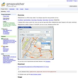
It can display maps from many providers such as: CloudMade, OpenStreetMap, Yahoo Maps, Bing Maps, Nokia Maps, SkyVector, Google Map. It displays them using a custom GUI. User can view the maps while offline. GMapCatcher is written in Python 2.7 & PyGTK, can run on Linux, Windows and Mac OSX. You can find a list of improvements and latest features in the Changelog Download or $ svn checkout gmapcatcher For Windows users, get the latest Windows installer Usage maps.py is a gui program used to browse google map. After version 0.04, user can force GMapCatcher to re-download old map tiles by checking "Force update". Download.py is a downloader tools that can be used to download map tiles without gui. maps can use files it downloaded without configuration. Below is an example using download.py: $ download.py --location="Paris, France" --max-zoom=16 --min-zoom=0 --latrange=2.0 --lngrange=2.0 Files Linux: $HOME/.GMapCatcher/* Windows: Dependencies Authors.
Google Maps Saved Locations. Scribble Maps - Create custom google maps with scribblings and more! Hybrid Road Satellite Terrain Update Log April 21, 2014 Rolled out MapYourList.com Rolled out improvements for large marker sets Fixed some issues with widget current views We have created a new product that makes it super easy to map lists or spreadsheets.

Use the gear icon below to change settings like metric/imperial and marker clustering. Change Map Type and vendor. Zoom the map in and out. $5/month or $50/year Delist and Password protect (secure) maps. Complete Access to pro.scribblemaps.com Remove ads from scribblemaps.com Remove ads from any published widgets. Get map images up to 1500x1500 pixels Upgrade to VIP! By month ($5) By Year ($50) Le GéoWeb pour les nuls.
Tout ce que vous avez voulu savoir sur le GéoWeb sans oser le demander ?
Plus modestement quelques éléments de base pour réfléchir: les infrastructures logicielles, le GéoWeb volontaire et le GéoWeb subreptice, les outils d’analyse du GéoWeb, ses promesses, ses limites, ses dangers et une question finale : le GéoWeb, outil local, outil global ? D’accord, c’est surtout le titre de ce billet qui est nul mais son objectif est le même que celui de la fameuse collection : expliquer en termes simples à un public de curieux un sujet qu’il ne connaît pas. L’idée m’en est venue après ma participation à l’émission de Sylvain Kahn sur France-Culture Planète Terre en compagnie de Patrick Poncet.
Nous tentions de répondre de manière non technique et forcément synthétique à cette question périlleuse: « Internet, une nouvelle géographie ? » J’ai donc repris et étendu le texte que j’avais fourni à Sylvain Kahn et qui se trouve sur Globe, le blog de l’émission. GOOGLE EARTH. KML Reference - KML - Google Code. This section contains an alphabetical reference for all KML elements defined in KML Version 2.2, as well as elements in the Google extension namespace.

The class tree for KML elements is shown below. In this diagram, elements to the right on a particular branch in the tree are extensions of the elements to their left. For example, Placemark is a special kind of Feature. It contains all of the elements that belong to Feature, and it adds some elements that are specific to the Placemark element. KML is an open standard officially named the OpenGIS® KML Encoding Standard (OGC KML). The complete XML schema for KML is located at Note: Click an element name in this diagram to jump to its entry in the reference section. Note that abstract elements (shown in boxes in the diagram) are not actually used in KML files. All elements derived from Object can have an id assigned to them. Because KML is an XML grammar and file format, tag names are case-sensitive and must appear exactly as shown here.
<! Le Petit Bazar Cartographique > Recherche.