
FREE British Isles and Ireland Maps Home (talkytoaster) British Geological Survey (BGS) Geology of Britain viewer The Geology of Britain viewer combines a number of key British Geological Survey data products in a single viewer.
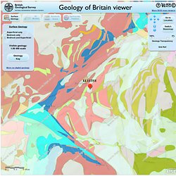
To facilitate this, the viewer can operate in one of four modes: To switch modes, use the 'Surface Geology', '3D Models', 'Borehole Scans' and 'Earthquake Timeline' buttons located under the banner. Surface Geology mode In this mode, the viewer displays either bedrock geology, superficial deposits or a combined map showing both bedrock geology and the overlying superficial deposits (the default). Click on the map to bring up an information window giving details of the geology at that location.
Click on the geology key button to view a key of the currently visible geology. At the full extent, 1:625 000 scale geology is displayed. 5% of 1:50 000 scale data is unavailable for England, Scotland and Wales. 3D Models (Groundhog) mode To interrogate a model, first choose a model of interest from the drop down list. Borehole Scans mode Earthquake Timeline mode. The GeoCommunity: Conversion of Shapefile to KML : An overview of tools available. m2i. The next most obvious thing. Dotspotting - Low & Behold! Garmin Edge 800 In Depth First Look Review. What exactly is the Edge 800 you ask? Well, it’s a new bike computer that aims to provide all of the cycling features you’d expect from the Edge series (ANT+ support, power meter compatibility and configuration, GPS route recording and workout capabilities), and combine it with features from not only the higher end Edge 705, but also from many of Garmin’s outdoor line of products that allow you to include satellite imagery – known as Birdseye Satellite imagery and custom maps, which we’ll get into in a bit.
In effect, this is combing the best of both words – the smaller form factor closer to the Edge 500, but with a higher resolution screen and far more features than the last generation Edge 705 – all with the fill-in features like a touch-screen from the outdoor/hiking units…finally, in a price about half-way in between. Like all my reviews, they tend to be pretty in depth (perhaps overly so) – but that’s just my trademark DC Rainmaker way of doing things. Unboxing: Virtual Partner: Www.gaslampmap.com/GaslampMap_2012.pdf. Google Maps. Mobile - les cartes et itinéraires ViaMichelin sur votre mobile. Plan routes for multi-activities (hiking, running, cycling, horse riding etc) - Display the elevation profile - calculate distance and cumulated height - Export and Import GPS Tracks.
L’interface de planification de parcours évolue, avec un tout nouveau gestionnaire de fonds de carte: Le passage d’un fond de carte à l’autre, IGN France, Google Maps, OpenStreetMap,SwissTopo, etc. s’effectue plus simplement. Le parcours est désormais automatiquement fléché L’affichage des points est optimisé en fonction du niveau de zoom pour plus de fluidité La fonctionnalité de suppression de n points d’un tracé a été ajoutée, idéale pour nettoyer une trace GPS Les gagnants de ce jeu-concours sont: Philippe CHARPIN Pascal COMMES Mickaël DIANCOURT Louis GIAVARINI François LANNES Marc LEROYER Cyril LIN WEE KUAN Valérie MARTIN Jean-Luc MARTY Patrick VERHAEGHE Bravo à eux et merci à tous les participants.
Le (20km/1000m D+) se déroulera le au coeur du et à quelques foulées du . Nouveauté cette année, le est inscrit au . Openrunner et l’équipe organisatrice du Trail de la Biroussanne vous offrent des inscriptions pour l’édition 2012. Géoportail - le portail des territoires et des citoyens. Cartes de Cassini en couleur en grand format.