
ITO Map - Speed limits mph. Grab a Grid Reference Duo. 2079/100000 OS tiles used today Drag the red marker on the left map to where you want a National Grid reference*.
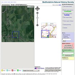
(The blue marker on the right map cannot be dragged). The grid refs will appear on the right, and the corresponding boxes are drawn on both maps. Please do not record using 2km or 10km grid refs. These are for information only. Nvert between Latitude/Longitude & OS National Grid Reference points. Some people have asked me about converting between latitude/longitude & Ordnance Survey grid references.
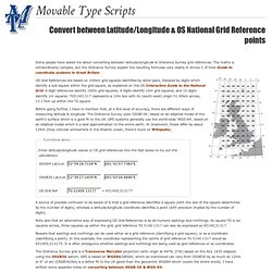
The maths is extraordinarily complex, but the Ordnance Survey explain the resulting formulae very clearly in Annex C of their Guide to coordinate systems in Great Britain. OS Grid References are based on 100km grid squares identified by letter-pairs, followed by digits which identify a sub-square within the grid square, as explained on the OS Interactive Guide to the National Grid. 6-digit references identify 100m grid squares; 8 digits identify 10m grid squares, and 10 digits identify 1m squares. TG51401317 represents a 10m box with its (south-west) origin 51.40km across, 13.17km up within the TG square.
Before going further, I have to mention that, at a fine level of accuracy, there are different ways of measuring latitude & longitude. The Ordnance Survey uses ‘OSGB-36’, based on an elliptical model of the earth’s surface which is a good fit to the UK. Find latitude and longitude with Google Maps.