
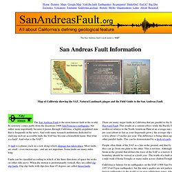
Lifornia's Big Earthquakes. Information and resources about the San Andreas Fault. There are many major faults in California that are parallel to the SAF, like the Hayward Fault.
This results in a curious effect: while the Pacific Plate is moving northwest relative to the North American Plate at an average rate of about 2.5 inches per year (about as fast as your fingernails grow), the average slip rate along the SAF is less, about 1.5 inches per year. The difference is being taken up by slip along the other parallel faults. This can be demonstrated by a deck of cards. People often think of the SAF as a line in the ground, and that by hopping across it, they can go from one plate to the other.
This is not true. California is famous for its earthquakes on the SAF (1906 San Francisco Earthquake, 1857 Fort Tejon earthquake), but the state's quakes are not particularly large. The SAF is about 28 million years old. 1000 miles x 5280 ft/mile x 12 inches/ft = 63,360,000 inches At the measured slip rate of about 2.5 inches per year, it will take. All About the San Andreas Fault. The San Andreas fault is a crack in the Earth's crust in California, some 1100 kilometers long.
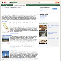
Many earthquakes have occurred along it, including famous ones in 1857, 1906 and 1989. It marks the boundary between the North American and Pacific lithospheric plates. Geologists divide it into several segments, each with its own distinct behavior. A research project has drilled a deep hole across the fault to study the rock there and listen for earthquake signals. And the geology of the rocks around it sheds light on the fault's history. Where It Is Geology Guide image from US Geological Survey map The San Andreas fault is the foremost of a set of faults along the boundary between the Pacific plate on the west and the North America plate on the east. The Northern Segment Geology Guide photo. California Earthquake Information. Se préparer à un séisme en Californie - Californie Sud.
« The Big One » ; le nom fait déjà trembler.

Selon les experts, ces méga-séismes qui avaient déjà tué et détruit en 1857 et 1906, menaceraient la Californie d’ici 2030. Même si la fréquence d’un telle catastrophe est relativement basse, le sol californien est régulièrement secoué par des séismes de plus faible amplitude. Que faire en cas de tremblement de terre et comment l’anticiper ? Quels sont les organismes et les médias à connaitre pour s’informer ? Voici quelques pistes pour se préparer le mieux possible à la colère de la terre. Bon à savoir Déjà rompue en 1906 lors d’un tremblement de terre d’une magnitude de 7,8 sur l’échelle de Richter, la faille de San Andreas est supposée faire ébranler le sol Californien une nouvelle fois entre 2000 et 2030. Mieux comprendre pour mieux se préparer Pour les passionnés de la tectonique des plaques et pour ceux qui veulent comprendre comment ça marche, voir les explications exhaustives sur Geologie.Ens.fr/~Vigny/Tecto-F ou IPGP.fr/Pages/0611.
List of earthquakes in California. Earthquakes in California are common occurrences since the state is located on the San Andreas Fault, which cuts across California and forms the tectonic boundary between the Pacific and the North American Plate.
There are many thousands of small earthquakes per year, most of them so small that they are not felt. California's complex landscape can be attributed to the network of faulting that runs through the state. The earliest reported earthquake in California was felt in 1769 by the Portola expedition about 30 miles southeast of Los Angeles, probably near the San Andreas Fault.[1][2] Summary[edit] The largest recorded earthquake in California was the 1857 Fort Tejon earthquake, with an estimated magnitude of 7.9.
Earthquakes[edit] Note: Listed items include earthquakes with epicenters that are offshore, in an adjacent U.S. state, or in Baja California, Mexico. See also[edit] References[edit] Sources External links[edit] Les séismes aux Etats-Unis. Californie Le pire séisme qui a secoué la Californie, autour de San Francisco, est celui du 18 avril 1906 : magnitude 7,7, 3.000 morts.
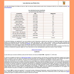
La ville de Los-Angeles est située sur la faille de San Andreas, et le risque de séisme y est très élevé. De nombreux spécialistes craignent qu'un séisme majeur s'y produise un jour, avec dans les scénarios les plus pessimistes une modification de la géographie locale liée à une séparation des terres à l'ouest de la faille du reste de la Californie. The big one est le terme employé par les Californiens pour désigner ce séisme majeur à venir. L'étude des tremblements de terre passés démontre que les dommages aux composants opérationnels et fonctionnels des bâtiments entraînent habituellement plus de blessures, de décès et de pertes matérielles et financières que les dommages structuraux.
Le 17 octobre 1989, un séisme de magnitude 7,1 a provoqué incendies, effondrement d'autoroutes, rupture du Bay Bridge à San Francisco. Article.