
Indo_gl2.mov (video/quicktime Object) PmelTITOV-INDO2004.mov (video/quicktime Object) News Online (Story 2365) Jan 10, 2005 After reviewing data from four Earth-orbiting radar satellites, NOAA scientists today announced they were able to measure the height of the devastating tsunami that erupted in the Indian Ocean.
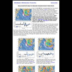
The ability to make depth surveys from space may lead to improvements in the models that forecast the hazardous effects of tsunamis. (Click NOAA image for larger view of tsunami wave height as measured by satellites two hours after the event. Click here for high resolution version, which is a large file. Click here for PDF version. Please credit “NOAA.”) Pmelmaxcomputedamplitude.gif (GIF Image, 1220x703 pixels) Pmelwavetraveltime.gif (GIF Image, 1090x706 pixels) Indian Ocean Tsunami Disaster December 2004: a Select Guide - University at Buffalo Libraries. Indian Ocean Tsunami Disaster December 26, 2004 and Reconstruction History & Events (Including Current) Maps & Images Relief Efforts & Contacts Tsunami Science.