
EIA. International Environmental Policy. Systems Dynamics. Principles of Remote Sensing - Centre for Remote Imaging, Sensing and Processing, CRISP. Optical remote sensing makes use of visible, near infrared and short-waveinfrared sensors to form images of the earth's surface by detecting thesolar radiation reflected from targets on the ground.
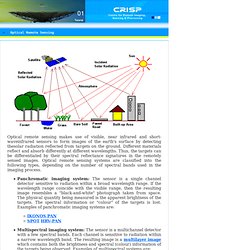
Different materials reflect and absorb differently at different wavelengths. Thus, the targets can be differentiated by their spectral reflectance signatures in the remotely sensed images. Optical remote sensing systems are classified into the following types, depending on the number of spectral bands used in the imaging process. Solar Irradiation.
Ecology. Environmental Law. Worldometers - real time world statistics. Waste management. Introduction to GIS. Sustainability Marketing. Ceres.