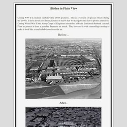

Infographic of the Day: Is Bottled Water Really That Bad? Yes. Hiding the Lockheed Plant during World War II - wow this is amazing! Hidden in Plain View During WW II Lockheed (unbelievable 1940s pictures).

This is a version of special effects during the 1940's. I have never seen these pictures or knew that we had gone this far to protect ourselves. The Ocean Sands of the Bahamas {Photo of the Day} – Planetsave.com: climate change and environmental news. This image depicts actual landforms on Earth, rather than what it might look like at first glance, a new-age painting on a sidewalk somewhere.

Taken by the Enhanced Thematic Mapper plus (ETM+) instrument aboard the Landsat 7 satellite on January 17, 2001, and depicts the sands and seaweed in the Bahamas. Source: NASA Goddard Tags: Bahamas, Earth, Landsat 7, Landsat program, NASA, Photos, Tassili n'Ajjer, United States, United States Geological Survey About the Author Joshua S Hill I'm a Christian, a nerd, a geek, a liberal left-winger, and believe that we're pretty quickly directing planet-Earth into hell in a handbasket! Green, Healthy & Safe Product Ratings & Reviews. WATERLIFE - NFB. Infographic: United States of the Environment.
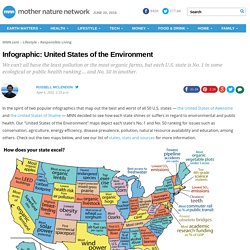
In the spirit of two popular infographics that map out the best and worst of all 50 U.S. states — the United States of Awesome and the United States of Shame — MNN decided to see how each state shines or suffers in regard to environmental and public health.

Our "United States of the Environment" maps depict each state's No. 1 and No. 50 ranking for issues such as conservation, agriculture, energy efficiency, disease prevalence, pollution, natural resource availability and education, among others. Check out the two maps below, and see our list of states, stats and sources for more information. Cancer.