
Statistics and its relationship to accuracy measure in GPS. C# - How to calculate accuracy of latitude/longitude - GIS. Current community your communities Sign up or log in to customize your list. more stack exchange communities Stack Exchange sign up log in tour help Geographic Information Systems Ask Question Take the 2-minute tour × Geographic Information Systems Stack Exchange is a question and answer site for cartographers, geographers and GIS professionals.
How to calculate accuracy of latitude/longitude 1 Answer active oldest votes Your Answer Sign up or log in Sign up using Google Sign up using Facebook Sign up using Stack Exchange Post as a guest discard By posting your answer, you agree to the privacy policy and terms of service. Not the answer you're looking for? Related How to convert coordinates from Gauss-Krueger to Longitude/Latitude? How to create GRASS scripts in C# in Windows Convert latitude and longitude into northings and eastings Calculate Latitude and Longitude from Range, Azimuth, and Elevation Draw a skyplot with calculated ECEF values (in meters) Dilution of precision (GPS) Dilution of precision (DOP), or geometric dilution of precision (GDOP), is a term used in satellite navigation and geomatics engineering to specify the additional multiplicative effect of navigation satellite geometry on positional measurement precision.
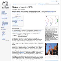
Understanding the Geometric Dilution of Precision (GDOP) with a simple example. In A someone has measured the distance to two landmarks, and plotted their point as the intersection of two circles with the measured radius. In B the measurement has some error bounds, and their true location will lie anywhere in the green area. In C the measurement error is the same, but the error on their position has grown considerably due to the arrangement of the landmarks.
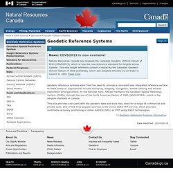
Navigation satellites with poor geometry for Geometric Dilution of Precision (GDOP). Navigation satellites with good geometry for Geometric Dilution of Precision (GDOP). Conceptually you can imagine errors on a measurement resulting in the term changing. GPS Tracking System. Tools and tips for GPS navigation and mapping. News: CGVD2013 is now available!
Natural Resources Canada has released the Canadian Geodetic Vertical Datum of 2013 (CGVD2013), which is now the new reference standard for heights across Canada. This new height reference system is replacing the Canadian Geodetic Vertical Datum of 1928 (CGVD28), which was adopted officially by an Order in Council in 1935. Read more Geodetic reference systems stem from the need to provide a consistent and integrated reference surface for data analysis. Applications include surveying, mapping, navigation, remote sensing and mineral exploration amongst others. This site provides end-users with the geodetic data and tools they need for a range of commercial and private uses. Date modified: OpenStreetMap & Via Alpina. Openstreetmap - GPS device taking pictures and saving heading + HDOP? - GIS. Current community your communities Sign up or log in to customize your list. more stack exchange communities Stack Exchange sign up log in tour help Geographic Information Systems Ask Question Take the 2-minute tour × Geographic Information Systems Stack Exchange is a question and answer site for cartographers, geographers and GIS professionals.
GPS device taking pictures and saving heading + HDOP? 3 Answers active oldest votes Your Answer Sign up or log in Sign up using Google Sign up using Facebook Sign up using Stack Exchange Post as a guest discard By posting your answer, you agree to the privacy policy and terms of service. Not the answer you're looking for?
Get the weekly newsletter! Top questions and answers Important announcements Unanswered questions. CGIAR-CSI SRTM 90m DEM Digital Elevation Database. Android Application Development Tutorial - 142 - LocationManager and Location Permissions. Open-gpstracker - A GPS tracking Android App: Build to be extensible and Free. Getting started tracking your adventures using Android device to track your GPS routes. Download and install Open GPS Tracker Record a track using Open GPS Tracker.
This video steps you through the process. Sign up to Breadcrumbs. You can do this through your mobile browser if you want. Make sure you wait for the email to activate your account. Register Open GPS Tracker with Breadcrumbs (you only have to do this once) During your first upload (see Step 5), Open GPS Tracker will re-direct you to the Breadcrumbs login page.
Note: Any Android GPS tracking app that allows you to export your track as a GPX file is supported by Breadcrumbs via our GPX support .