
ABCNews Maps Haiti. CNN Maps Haiti. WSJ 3Maps Interactive Haiti. UNOSAT. ReliefWeb Maps Haiti. NYT Maps Haiti. ESAsatellite map Haiti earthquake. Port-au-Prince, Haiti First satellite map of Haiti earthquake 14 January 2010 A major 7.0-magnitude earthquake struck the Haitian capital of Port-au-Prince on 12 January, causing major casualties and damage.
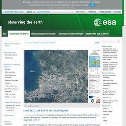
The quake was followed by several aftershocks with magnitudes over 5.0. Map FieldHospitals IDPs Port-au -Prince.