
The National Map. Digital Map - Beta. US Topo quadrangles are digital topographic maps produced by the National Geospatial Program of the U.S.
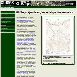
Geological Survey (USGS). Created in the familiar 7.5-minute quadrangle format like the legacy paper maps, US Topo maps support frequent updating, wide and fast public distribution, and basic, on-screen geographic analysis. US Topo maps are available for free Web download from the USGS Store. The National Map.