
Fusion Tables in Maps API v3. Tool for Google Maps v3 (version 3) This application is also available with Large map.
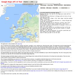
This is a drawing tool for polyline, polygon, polygon with holes, rectangle, circle, marker(icon), direction(route, path). This application uses the Google Maps API Version 3 (V3). It has all the features of Google Maps MyMaps and has direct access to the code for the shapes (overlays) you create. It should be a full-fledged alternative. You draw and create a map with the shapes you want. Code will be presented in the textarea. The OpenStreetMap map type has been added to the Google Maps map types. The feature 'polygon with hole' ('donut') is built-in in V3. The V2 feature enableEditing now exists for V3. And for editing - if you have a kml file uploaded on a server, and you want to edit its coordinates, you may use my edit tool Edit tool for Google maps polyline and polygon You will need a PC or laptop with a large amount of computer memory if your kml file has 1000 coordinate pairs or more.
Other useful links: Public transit routing and layer now available in the Google Maps API. Google Maps API now enables developers to add Transit data, including public transit directions, to their maps and apps.
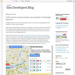
Whether you're planning a trip from your computer or on the spur of the moment from your mobile device, Google Maps helps you find directions in more than 475 regions around the world. Today we're pleased to announce that public transit directions are now available in the Google Maps API. Public transit has been one of the most requested features by Maps API developers, and you can now use it in both the Google Maps Javascript v3 and the Directions Web Service. It's simple for you to update your apps to also offer routing by public transit in addition to driving, bicycling, and walking. The transit route responses include the number of stops, direction of travel and more. To support the launch of routing by public transit we're also adding the Transit Layer to the Maps API. Google Maps API Receives Transit, Symbols, Heatmap Layers. Google has made several modifications to its Google Maps strategy over the past few weeks that will encourage developers to continue to use the service.
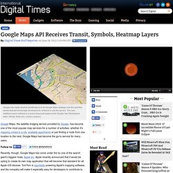
The new additions were outlined in a recent blog post made by the Google Geo-Developers team. (Photo: flickr.com / Johan Larsson) Google Maps, the satellite imaging service provided by Google, has become one of the most popular map services for a number of activities: whether it's mapping crimes in a city, available apartments or just finding a route from one location to the next, Google Maps has become the go-to service for many users. Follow Us Recently, though, Google Maps has come under fire by one of the search giant's biggest rivals, Apple Inc. Not to be outdone, Google has made several modifications to its Google Maps strategy over the past few weeks that will encourage developers to continue to use the service.
"To support the launch of routing by public transit we're also adding the Transit Layer to the Maps API.
Set map styles - Google Fusion Tables Help. Locations in Fusion Tables can be points, lines or polygons.
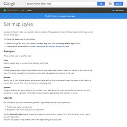
The appearance of each of these features on the map can be set with a map style. To change the appearance of map features: Style types There are four ways to specify a style: Fixed Specify a single style to be used for all elements on the map. Column Provide a specification for each row's display in one of your table's data columns.
Buckets Specify two or more number ranges, and give each range a style. Gradient Polygons and lines are styled based on the numbers in your data. Google Maps API links. Convertor Test.