
Benjamin Grant’s New Perspective Of Earth. Titled ‘Overview’ the new book of author Benjamin Grant shows a unique collection of breathtaking, high definition satellite photographs of our planet that capture many ways people have transformed the Earth.
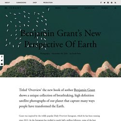
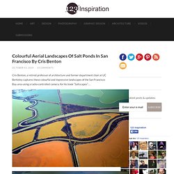
Grant was inspired by the wildly popular Daily Overview Instagram, which he has been running since 2013. As the Instagram has swelled to nearly half a million followers, some of the best images have been collected for a miscellany. The project was developed during a space expedition by astronauts who spend extended periods of time in cosmic space. The book contains more than 200 original images of industry, agriculture, architecture, and nature that demonstrate graphically breathtaking patterns across the Earth’s surface. Colourful Aerial Landscapes Of Salt Ponds In San Francisco By Cris Benton. Cris Benton, a retired professor of architecture and former department chair at UC Berkeley captures these colourful and impressive landscapes of the San Francisco Bay area using a radio-controlled camera, for his book “Saltscapes”…
Stunning Aerial Photos of Italian Beach Resorts In Adria By Bernhard Lang. Munich-based photographer Bernhard Lang has created a series of impressive aerial photos of Italian beach resorts in Adria… All images © Bernhard Lang.

Daily Overwiew changes your perception of Earth. Daily Overview is an amazing project that shares one satellite photo from Digital Globes a day in an attempt to change the way we see our planet Earth.
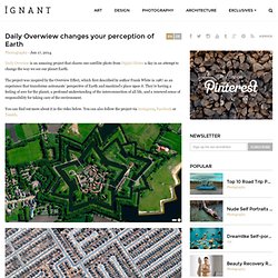
The project was inspired by the Overview Effect, which first described by author Frank White in 1987 as an experience that transforms astronauts’ perspective of Earth and mankind’s place upon it. They’re having a feeling of awe for the planet, a profound understanding of the interconnection of all life, and a renewed sense of responsibility for taking care of the environment. You can find out more about it in the video below. You can also follow the project via Instagram, Facebook or Tumblr. Tito Mouraz. Die Serie ‘Open Space Office’ wurde von Tito Mouraz über einen Zeitraum von 2 Jahren in Portugal aufgenommen.
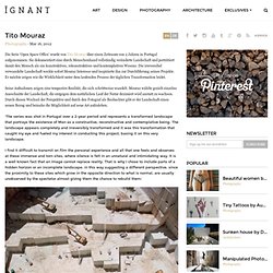
Sie dokumentiert eine durch Menschenhand vollständig veränderte Landschaft und porträtiert damit den Mensch als ein konstruktives, rekonstruktives und kontemplatives Wesens. Harbor Aerial View Photography. Paul0v2 Tue, 11/12/2013 - 13:39 I never imagined seeing a Harbor from an aerial view and now that I did it's super awesome, so many colors and shapes make you feel on a game of tetrix. Take a look how small everything is and how cool is the view from above. Enjoy! These photos were taken by German photographer Bernhard Lang, for more visit bernhardlang.de/. Share this post with your friends and followers using: Aerial Photos of Botswana Wildlife. Zack Seckler created pictures of animals, vegetation and salt ponds in Botswana from 500 feet above the ground.
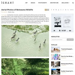
The result is a series of images that are an aesthetic mixture between landscape and pattern. The photographer describes his experience: ‘Being above the ground at such low elevations, and having the ability to precisely maneuver, was like gliding over an enormous painting and being able to create brushstrokes at will. As soon as I saw the landscape from above I knew there was potential to create a special body of work.’ The effect is pure beauty. You can see the series at Robin Rice Gallery in New York until February 23, 2014. Kite Aerial Photography: Seeing the World from New Heights. Sometimes, pointing and clicking just isn’t enough.
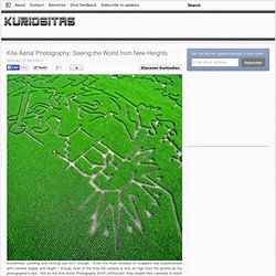
Even the most amateur of snappers has experimented with camera angles and height – though most of the time the camera is only as high from the ground as the photographer's eye. Not so the Kite Aerial Photography (KAP) enthusiast: they enable their cameras to reach for the sky with often spectacular results. Observing the Earth, Beautiful Satellite Photos of Earth from the ESA. iGNANT. On a trip to Sicily, Mauritius and Morocco photographer Joseph Ford spent several days flying around over all sorts of terrain in a helicopter.
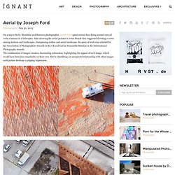
After showing the aerial pictures to some friends they suggested shooting a series mixing fashion and landscapes. Juxtaposing clothes and aerial landscape, the piece of work was selected for the Association of Photographers Awards in the UK and had an Honorable Mention in the International Photography Awards. Aerial photographer. Jason Hawkes. Aerial Photography. Kaleidoscope-Inspired Aerial Landscape Photography by David Thomas Smith.
Galería Marlborough Madrid y Barcelona. Large-scale Urban Photography by Andreas Gursky. Andreas Gursky is a German visual artist known for his large format architecture and landscape color photographs, often employing a high point of view.
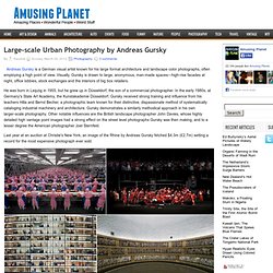
Visually, Gursky is drawn to large, anonymous, man-made spaces—high-rise facades at night, office lobbies, stock exchanges and the interiors of big box retailers. He was born in Leipzig in 1955, but he grew up in Düsseldorf, the son of a commercial photographer. In the early 1980s, at Germany's State Art Academy, the Kunstakademie Düsseldorf, Gursky received strong training and influence from his teachers Hilla and Bernd Becher, a photographic team known for their distinctive, dispassionate method of systematically cataloging industrial machinery and architecture. Gursky demonstrates a similarly methodical approach in his own larger-scale photography.
Last year at an auction at Christie's New York, an image of the Rhine by Andreas Gursky fetched $4.3m (£2.7m) setting a record for the most expensive photograph ever sold. Otherworldly Winter Photos Captured Dangerously - While Paragliding. Creative Aerial Photography by David Maisel. “O Campo” by Joachim Schmid. Joachim Schmid apresenta sua mais recente obra “O Campo” Brazilian Football Fields, é uma compilação fotográfica de campos de futebol nas cidades brasileiras.
As imagens foram tiradas por satélite, mostram campos de futebol de formas estranhas, parecem ser construídos sempre em locais impossíveis, demonstram claramente que o desejo de jogar futebol ultrapassa e ignora as limitações da topografia natural e também as leis da FIFA. Um projeto que utiliza imagens do Google Earth tomadas em campos de futebol de atletas amadores, a conhecida várzea, Schmid que vive e trabalha em Berlim, é um dos primeiros artistas que basearam seu trabalho sobre o uso de imagens que encontrou em torno de materiais fotográficos pré-existente.
BLDGBLOG: Ice Age Aerial. [Image: Photo: The "cemetery and church at Teampull Eion, Isle of Lewis," courtesy of the Royal Commission on the Ancient and Historical Monuments of Scotland]. One of many things I was excited to discover while working on the British Exploratory Land Archive project, and while getting ready for tonight's lecture at the Architectural Association, is the "Scotland's Landscapes" collection of aerial archaeology photographs from the Royal Commission on the Ancient and Historical Monuments of Scotland.
[Image: (top) The "remains of White Castle Fort"; (bottom) the "remains of the Northshield Rings. " Photos courtesy of the Royal Commission on the Ancient and Historical Monuments of Scotland]. "As the glaciers of the last Ice Age receded," we read, "Scotland's earliest ancestors ventured northwards, exploring a wild, fertile territory. Nomadic hunter-gatherers at first, they made the decision to stay for good—to farm and to build. Aerial Photographs of Ethiopia's Danakil Desert, the Hottest Place on Earth. Jamey Stillings - Project Photography on the Ground and in the Air. Joachim Schmid. O Campo, or in its translation The Field, is a series of photographs of football fields in Brazilian cities. The images were taken via satellite and they show the rather oddly shaped football pitches that seem to be built wherever possible – the desire for playing the game has clearly surpassed and ignored the limitations of natural topography and FIFA’s laws of the game.
According to the official rules and regulations you would not be allowed to play football on any of these fields. However, the careers of many of the world’s best football players began on these very same fields despite their askew angles, odd proportions, mis-shapen border lines and pitch markings. Aerial Nudes - John Crawford. Aerial photographer. Jason Hawkes. Aerial Photography. Zhang Kechun. Für die Serie ‘Yellow River’ reist Zhang Kechun entlang des Huáng Hé, des gelben Flusses. Der Huáng Hé entspringt in den ausgedehnten Weiten des Hochlandes von Tibet und bahnt sich seinen Weg durch den Nordosten Chinas bis er, nach etwa 5.000 Kilometern in den Golf von Bohai mündet. Entlang des Flusses findet man alle Arten von Leben, von Natur, von Städten und Menschen. Man findet Ruhe und Turbulenzen, man sammelt Gesichter und Geschichten, Skurriles und Banales. Zhang Kuchan entschloss sich dem kurvigen Lauf des Flusses zu folgen und dokumentiert mit seiner Kamera was ihm unterwegs begegnete, genau wie er angezogen von den vom Löss gefärbten, gelben Fluten.
‘It is a river! Bas Princen. Rotterdam-based photographer Bas Princen was first trained as an architect, before earning a reputation for documenting the vast structures and spaces he might once have helped create. With his photographs of giant construction sites and apparently absurd human artefacts he describes the oddity of human ‘civilisations’. ‘I go out to find photographs in which the artificial and the natural take each other’s forms and in which one is unable to see if things are being constructed or destroyed. I think that is the most interesting thing that can be said right now about the cities in which we live, and the landscapes in which we dwell (and vice versa).’ Aerial Photos of Tulip Fields In The Netherlands. Aerial Photography by Bernhard Edmaier. This fantastic aerial photo of NYC turns Manhattan into 'Sim City'
Breathtaking Aerial Photography by Klaus Leidorf. Breathtaking aerial landscape photographs by German photographer Klaus Leidorf… Klaus Leidorf | 500px | flickr. Kim Høltermand. Schon einmal haben wir bei iGNANT über Kim Høltermand berichtet. Damals hat der Berufspolizist und freiberuflich arbeitende Fotograf seine Heimatstadt Kopenhagen als ‘Deserted City’ in geheimnisvolle Nebel getaucht abgelichtet. Seine neue Serie ‘Monochronos’ widmet sich ganz der schwarz-weiß Fotografie und ist von der Arbeit des Fotografen Julius Schulmann inspiriert.
Brett Beyer. The Architectural Firm OMA recently completed construction of Milstein Hall at Cornell University’s College of Architecture Art, and Planning. Stunning Aerial Photography by Edward Burtynsky. Aerial Photography by Gray Malin. Stephan Zirwes. Hanging out of a helicopter, Stephan Zirwes questions our reality while the world is presented to him on a platter. He searches for patterns, structures, connections, uniformities and contrasts, is that a cornfield or a doormat? Hong Kong Streets Transformed Into a Retro 2D Games. ‘Honkey Kong’, a brilliant photo series by Stockholm-based photographer Christian Åslund. The photos were created as part of an ad campaign for the shoe brand Jim Rickey… Life On The Edge. Edgar Martins. From Below. Room Portraits. House Watch.