
Banksy sur Twitter : #earth... U.S.Geologic Survey: Earthquake risk increased for half of U.S. A new federal earthquake map dials up the shaking hazard just a bit for about half of the United States and lowers it for nearly a quarter of the nation.
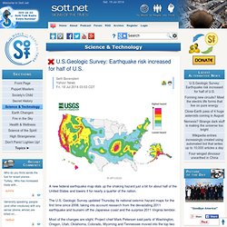
The U.S. Geologic Survey updated Thursday its national seismic hazard maps for the first time since 2008, taking into account research from the devastating 2011 earthquake and tsunami off the Japanese coast and the surprise 2011 Virginia temblor. Most of the changes are slight. Project chief Mark Petersen said parts of Washington, Oregon, Utah, Oklahoma, Colorado, Wyoming and Tennessee moved into the top two hazard zones. 4.1-magnitude earthquake shakes central Utah. 4.1-magnitude earthquake shakes central Utah By Michael McFall | The Salt Lake Tribune First Published 7 minutes ago • Updated 3 minutes ago A small earthquake Saturday evening rattled Sanpete County.
A preliminary report placed the estimated 4.1-magnitude earthquake’s epicenter about 3 miles southeast of Spring City, according to the University of Utah seismograph stations. Lt. County dispatchers had not received any reports of damage or injuries from the quake. mmcfall@sltrib.com Twitter: @mikeypanda. Relatively strong earthquake on the border of Germany and the Czech Republic (Vogtland)
Earthquake-report.com only survives with (mostly small) PRIVATE DONATIONS.
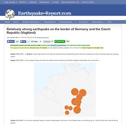
Your gift will be highly appreciated.This page will automatically refresh every 10 minutes as we might be adding updates. Do not close it but leave it open in a browser tab. – Update 16:01 UTC : In Stribrna (Cheb, Eger) the Fire and Rescue sericices have reported that some chimneys collapsed and that numerous walls are showing cracks. Magnitude 4.5 - CZECH REPUBLIC - 2014 May 31, 10:37:20 UTC. Source parameters provided by: GeoForschungsZentrum (GEOFON) -- Potsdam, Germany (GFZ) Regional instrumental seismicity.

South America. West. Volcanoes. Minor earthquake recorded in Summit County. Minor earthquake recorded in Summit County By bob mims | The Salt Lake Tribune First Published Mar 14 2014 12:43 pm • Last Updated Mar 14 2014 10:09 pm A minor earthquake rattled a remote area of north-central Utah’s Wasatch Mountains late Friday morning, but caused no damage to nearby communities.
Seismological Society of America: Fracking causes earthquakes. 4.8 magnitude earthquake in Yellowstone National Park. YELLOWSTONE VOLCANO OBSERVATORY INFORMATION STATEMENTSunday, March 30, 2014 10:31 AM (Sunday, March 30, 2014 16:31 UTC) YELLOWSTONE VOLCANO (VNUM #325010) 44°25'48" N 110°40'12" W, Summit Elevation 9203 ft (2805 m) Current Volcano Alert Level: NORMALCurrent Aviation Color Code: GREEN The University of Utah, a YVO member agency, sent out the following press release about a magnitude 4.8 earthquake that occurred this morning at 6:34 AM MDT.

PRESS RELEASE University of Utah Seismograph Stations Released: March 30, 2014 08:15 AM MDT The University of Utah Seismograph Stations reports that a light earthquake occurred at 06:34 AM on March 30, 2014 (MDT). Yellowstone Bison Running for their lives. Breaking! Second 7.5 magnitude eartquake in 12 hours strikes off Solomon islands. A tsunami warning has been issued after a strong, 7.5-magnitude quake hit near the Solomon Islands in the southwestern Pacific for the second time in hours.
It follows a 7.6-quake that rocked the region overnight. A shallow 7.7 magnitude earthquake, which was then revised down to 7.5, centered about 114 kilometers south of Kirakira, Solomon Islands and 20 kilometers deep shook the area, the US Geological Survey reported. A tsunami warning has been issued for Solomon Islands, Vanuatu and Papua New Guinea, according to the Pacific Tsunami Warning Center. USGS: Earthquake Magnitude 6.9 - 77km WNW of Ferndale, California. Ohio Earthquakes Linked To Fracking, A First For Region. COLUMBUS, Ohio (AP) — Geologists in Ohio have for the first time linked earthquakes in a geologic formation deep under the Appalachians to hydraulic fracturing, leading the state to issue new permit conditions Friday in certain areas that are among the nation's strictest.
A state investigation of five small tremors last month in the Youngstown area, in the Appalachian foothills, found the injection of sand and water that accompanies hydraulic fracturing, or fracking, in the Utica Shale may have increased pressure on a small, unknown fault, said State Oil & Gas Chief Rick Simmers. He called the link "probable. " While earlier studies had linked earthquakes in the same region to deep-injection wells used for disposal of fracking wastewater, this marks the first time tremors in the region have been tied directly to fracking, Simmers said. Was the Los Angeles Earthquake Caused by Fracking Techniques?
The epicenter of today's LA quake was eight miles from oil waste injection wells.
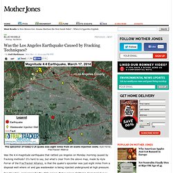
Kyle Ferrar, FracTracker Alliance Was the 4.4-magnitude earthquake that rattled Los Angeles on Monday morning caused by fracking methods? It's hard to say, but what's clear from the above map, made by Kyle Ferrar of the FracTracker Alliance, is that the quake's epicenter was just eight miles from a disposal well where oil and gas wastewater is being injected underground at high pressure. Don Drysdale, spokesman for the state agency that oversees California Geological Survey, told me that state seismologists don't think that the injection well was close enough to make a difference (and the agency has also raised the possibility that Monday's quake could have been a foreshock for a larger one).
But environmental groups aren't so sure. 9 earthquakes recorded in Oklahoma since Friday.