
Solar Eclipse: World Map of Future Eclipses. Comet Hunter’s Last Look at Earth Is Haunting. This gorgeous image of a blue arc of the Earth against the blackness of space was captured by the Rosetta spacecraft as it swung by our planet.
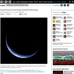
The European Space Agency mission is on its way to intercept the comet, 67P/Churyumov-Gerasimenko. The ship will deploy a lander onto the comet’s surface, the first such attempt to be made. To gather up the necessary energy to reach the comet out past Mars’ orbit, Rosetta needed three swings past Earth. This is its third and final flyby. It will reach the comet in early 2014. Unlike the most famous pictures of Earth, which show most of the blue marble, this photo presents a planet in darkness, just the South Pole awash in light. Image: ESA. See Also: Total Solar Eclipse of 2017 Aug 21. Google Maps and Solar Eclipse Paths Your web browser must have Javascript turned on.
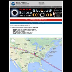
The following browsers have been successfully tested with Google Maps: Macintosh - Firefox 3.5+, Chrome 4+, Safari 4+, Opera 10.5+ Windows - Firefox 3.5+, Chrome 4+, Explorer 8+, Opera 10.5+ Linux - Firefox 3.5+, Chrome 4+ iOS - Safari Mobile 4+, Chrome 25+, Opera Mini 5+ Android - Android 2.3+, Firefox 19+, Chrome 25+ Introduction This interactive Google map shows the path of the Total Solar Eclipse of 2017 Aug 21. The green marker labeled GE is the point of Greatest Eclipse. Note that the central line of the eclipse (plotted in red) is banded by different colors for hundreds of miles east and west of the Greatest Duration marker. You can be hundreds of miles from the theoretical point of Greatest Duration and still enjoy totality lasting within a fraction of a second of the maximum possible (as long as you stay within several miles of the central line).
User Directions Eclipse Circumstances Footnotes. Deep Impact - The Vredefort Dome. HartRAO Home > Things to do > Visit Deep Impact - The Vredefort Dome Newsflash - 2005 July 14 - The Vredefort Dome is declared a World Heritage Site.

One hundred kilometers south west of Johannesburg, South Africa are the towns of Vredefort and Parys, the latter lying next to the Vaal river. The towns are a short deviation from the N1 highway to Cape Town. In an arc to the north and west of the towns is a partial ring of hills, some 70 kilometres in diameter. The hills are centred on Vredefort, which is shown by the letter "V" in the photograph below, taken from the Space Shuttle.
Credit: Earth Sciences and Image Analysis Laboratory, NASA Johnson Space Center (Image STS008-35-1296) From high altitude these hills bear a strong resemblance to the larger, near-circular ring of hills north-east of Vredefort, whose northern side, the Magaliesberg hills, cuts through Pretoria (letter "P") and whose southern side, the "Witwatersrand" ridge, cuts through Johannesburg (letter "J").