
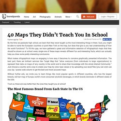
40 Maps They Didn’t Teach You In School. By the time we graduate high school, we learn that they never taught us the most interesting things in there.
Sure, you might be able to name the European countries or point New York on the map, but does that give a you real understanding of how the world functions? To fill this gap, we have gathered a great and informative selection of infographical maps that they should’ve shown us at school: every single one of these maps reveals different fun and interesting facts, which can actually help you draw some pretty interesting conclusions. Show Full Text What makes infographical maps so engaging is how easy it becomes to conceive graphically presented information. The best part, there are brilliant services like Target Map that “allow everyone (from individuals to large organizations) to represent their data on maps of any country in the world and to share their knowledge with the whole Internet Community.” Trust us, these are way better than the ones they taught you at school! The Future of the Map Isn't a Map at All—It's Information.
Google's vision for geospatial information: "We don't want a monoculture where there is just one map of the world.

There never has been; there never will be. " Google Maps can be beautiful, interesting, and, of course, useful, but there are a lot of questions we address to maps -- and these days, Google Maps specifically -- that maybe a map isn't the best tool for answering. Think of it this way. In the days before online trip planners and GPS, if you wanted to know how to get from point A to point B, you would look at a map and trace out a route. Directions aren't the only thing we use maps for that may be better answered by information. To Parsons, maps can be so much more than maps.
Parsons also has some interesting thoughts on the recent arrival of Apple into the mobile maps fray. Maps Before Maps. The Cartographer's Dilemma. In our History of Information Organization infographic, we highlighted cartography as one of the earliest forms of conceptual communication.

The first maps appeared during the Stone Age and appear to predate written language by several millennia. Maps developed as intuitive and functional representations of our physical surroundings—water this way, shelter that way. In order to highlight important geographic features, maps must filter out less critical details. And when an inch equals a mile, the omissions outnumber the inclusions. The cartographer’s dilemma should be familiar to any project manager responsible for editorial decisions on content, especially for infographics and other data visualizations. Different maps serve different purposes and thus display different details. Distortions in world maps have always reflected the difficulty of presenting a round globe on a flat page.
Most map-making incongruities are more conceptual than geographic. Image Source: www.iStockphoto.com.
Intentional stereotyping maps. Visual map interpretation. Syllabus and All Readings. August 30, 2010// Week 1// Orienting Ourselves Updated syllabus: ‘Navigating Maps’ John Krygier and Denis Wood, “Ce n’est pas le monde (This is not the world)”.

From Rethinking Maps, Routledge 2010. J.B. Harley, 1989. Daston, Lorraine. September 6, 2010//Labor Day — No Class. Risiko2.jpg (500×375) Interactive Maps. Home · Maps are Territories. The Map Is Not the Territory i. The Map Is Not the Territory Revisited. The Map Is Not the Territory iii. This exhibition is the third in a series exploring the work of artists who use the visual language of maps together with map-making strategies and systems.

Curated by Jane England of England & Co gallery, in association with the James Hockey Gallery, this exhibition is an expanded version of the England & Co exhibition The Map Is Not the Territory ii in 2002. In response to the additional exhibition space at the Surrey Institute of Art & Design, this exhibition presents additional works and installations by more than thirty artists from Britain and abroad, including Susan Hiller, Jugoslav Vlahovic, Cornelia Parker, Satomi Matoba, Tracey Emin, Jonathan Callan, Chris Kenny, Jonathan Parsons, Langlands & Bell, Sue Stockwell, Michael Druks, Wenyon & Gamble, Layla Curtis, and Kathy Prendergast.
Since the 1960s artists have increasingly adopted the map as a vehicle for their ideas, and as a way of dealing with their own place in a changing world. Expo Cartografías contemporáneas. Obra Social "la Caixa" (vídeo sin editar. Material prensa)
Creative Mapping.