
Time series visualization tools geography. GeoTime - Oculus GeoTime - Visual Analysis Of Time Series Data. World History Timeline History - About Us. Timemap - Javascript library to help use a SIMILE timeline with online maps including Google, OpenLayers, and Bing. Timemap.js is a Javascript library to help use online maps, including Google, OpenLayers, and Bing, with a SIMILE timeline.
The library allows you to load one or more datasets in JSON, KML, or GeoRSS onto both a map and a timeline simultaneously. By default, only items in the visible range of the timeline are displayed on the map. Version 2.0.1 Now Up! Version 2.0.1 is primarily a maintenance release, fixing a number of small bugs and cleaning up a few things that weren't quite right in v.2.0. Anyone using v.2.0 should probably upgrade to v.2.0.1, as it is more stable and includes very few changes other than bug fixes and new unit tests.
Style and label map content - My Maps Help. Import data onto your map - My Maps Help. You can pull lots of geographical info into a map all at once.
Here's how: Step 1: Prepare your data You can import a CSV, TSV, KML, KMZ, GPX, or XLSX file, or a sheet from Google Drive. Note: You can import only one data file per layer, and each file can have up to 2,000 rows. Step 2: Import content Open My Maps on your computer. Places will be automatically added to the map and available in a list in the legend on the left. Troubleshooting imports. Earth Outreach - Tutorial: Creating Maps Using the My Maps Tab. This tutorial was originally written as a part of Google Earth Outreach, a program to encourage public benefit uses of Google's mapping products.
Google Earth Outreach is currently only available in English - we hope to make it available in more languages soon. Creating your own maps has never been simpler. With My Maps, you can mark locations, paths, and regions of interest on a personalized map, and share it with multiple people! You can even add descriptive text, embed photos and videos, and view your map on Google Earth. With My Maps, there are a number of exciting things you can do for your organization.
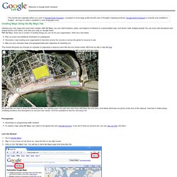
Plan an event and distribute information to participants. This tutorial will guide you through an example of organizing a cleanup event like the one shown below. We would like our map to show the following things: the meeting point, the path that each team will follow, the end point, and where we'll have our picnic at the end of the cleanup.
Prerequisites Let's Get Started! Earth Outreach. If you have Geographic Information Systems (GIS) data, you can import it into Google Earth Pro so you can use it as part of your visualizations.
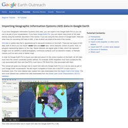
If you have Google Earth Pro, you can import many kinds of GIS data directly using the methods described in this tutorial. If you are using the free version of Google Earth, there are other tools for converting GIS data to KML, a few of which are listed at the end of this tutorial. GIS data is spatial data that is georeferenced to real-world locations on the Earth. How I created a Story Map using the ArcGIS Online Map Tour Template, a mobile phone and Flickr « Geography is everything. How I created a Story Map using the ArcGIS Online Map Tour Template, a mobile phone and Flickr Posted on Updated on If a picture speaks a 1000 words, then a map must speak 10,000.
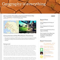
Combine a map with cemeteries and you have a lifetime of stories… Background A year ago I was not familiar with the term “Story Map”, but rather I concerned myself with creating maps to tell a story. There are many different types of maps and each map has a purpose, each with the aim of conveying particular information about an area to a group of people. With Esri Story Maps the process of building a map to tell that story is simplified. Identifying a theme This particular Story Map began after a visit to the George Brown Darwin Botanic Gardens. To maximise success of a theme for your Story Map you will need to: GIS and Genealogy. Spring 2014 Teaching GIS while learning about the past.
Trumpet your genealogy to the world. Genealogy GIS. Genealogy: People in Places When doing genealogical research about an ancestor you become something of a mini-expert on the places where they lived.
You discover the cemeteries, the size of the city at that time, where the census enumeration districts were, and where parish and county boundaries were. During your research you become grateful for the smalltown historical societies that exist in and care about their heritage enough to answer questions and preserve the institutional knowledge of available resources. In the end though, you spend a lot of time learning about places when what you want to learn about is people. Your people. GIS: We Have the Technology GIS systems can do amazing things with place information, with all the place related information in genealogy there must be some tasks which would be simplified through the use of GIS. The technology is ready now. Visualising Genealogy through Online GIS.