Space in Images - 2014 - 02 - Bouncing Sun. Les yoyos de l'oxygène sur Terre et la vie. Le site du Gabon où des fossiles de 2,1 milliards d'années ont été trouvés.L'oxygène est lié à la vie macroscopique et son histoire ancienne se révèle plus complexe montrent deux articles récents. Il y aurait eu un premier "pulse" d'oxygène, augmentant légèrement sa concentration dans l'air, il y a 3 milliards d'années, annonce un article publié par Nature jeudi dernier. Et la concentration en oxygène aurait fait le «yoyo» il y a 1,8 à 2,3 milliards d'années annonce un autre article, paru dans les PNAS lundi dernier. Ces publications montrent une nouvelle vision de l'histoire de l'oxygène... et donc de la vie sur la Terre à ces époques très anciennes dont les témoins géologiques sont très rares. S'il existe des organismes microscopiques qui vivent sans oxygène (bactéries et archées) il est indispensable aux organismes multicellulaires et de grande taille.
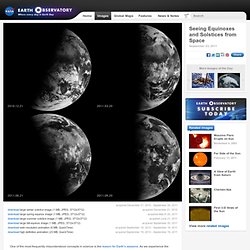
NASA releases photos of Earth taken from Saturn, Mercury. Earth is the blue dot in this wide image taken by the Cassini spacecraft at Saturn on July 19, 2013 from a distance of 898 million miles (1.44 billion km).

The dark side of Saturn, its bright limb, the main rings, the F ring, and the G and E rings are clearly seen; the limb of Saturn and the F ring are overexposed. Click for larger version. Credit: NASA/JPL-Caltech/Space Science Institute There are really awesome. Even better than I had imagined. This image of Earth and the moon was taken by NASA’s Cassini spacecraft on July 19, 2013. Pictures of Earth from space probes in the outer solar system are rare because our planet always appears close to the sun from their perspective. Another view of the blue Earth and moon taken by Cassini on July 19. The main image is only one frame of a much larger mosaic of 33 photos covering the entire ring system and globe of Saturn. Earth and moon look like a double star in the top photo taken at 6:54 a.m. La Terre photographiée depuis Saturne.
La NASA a publié un cliché de notre planète et de sa Lune prise le 19 juillet par la sonde Cassini qui orbite autour de Saturne à 1,44 milliard de kilomètres.
Plus de 20.000 personnes ont participé en «souriant pour la photo» ! Dans ce précédent article, nous vous expliquions que la sonde Cassini allait le 19 juillet à 23h27 heure française prendre une série de photos de Saturne en contre-jour et que la Terre serait dans le champ.Quatre jours plus tard, le Jet Propulsion Laboratory (JPL) de la NASA a publié un premier cliché extrait des 323 autres réalisés. Pourquoi autant d’images ? Parce que la caméra de Cassini ne peut pas photographier Saturne et ses anneaux en une seule fois : il lui faudrait un objectif véritablement grand-angle !
Ce sont donc 33 pointages qui ont été accomplis avec, à chaque fois, plusieurs clichés réalisés en employant des filtres différents, ce qui donne en tout 323 images. La Terre et la lune depuis Juno. This cosmic pirouette of Earth and our moon was captured by the Juno spacecraft as it flew by Earth on Oct. 9, 2013.

The two came into view when Juno was 600,000 miles (966,000 km) away. Credit: NASA/JPL-Caltech Remember when the Juno probe buzzed Earth last October? At 2:21 p.m. (CST) on Oct. 9, the Jupiter-bound spacecraft passed insanely close – just 347 miles (559 km) from Earth’s surface. The slingshot maneuver succeeded and Juno gained a whopping 8,800 mph (7.3 km/sec) of velocity. Enjoy the video at several different speeds along with a fitting soundtrack “If Captain Kirk of the USS Enterprise said, ‘Take us home, Scotty,’ this is what the crew would see,” said Scott Bolton, Juno principal investigator at the Southwest Research Institute, San Antonio. When you could WALK from New York to Morocco! How countries would look 300 MILLION years ago.
By Daily Mail Reporter Published: 05:02 GMT, 1 June 2013 | Updated: 18:37 GMT, 1 June 2013 A new map of Pangaea, the supercontinent from 300 million years ago, shows where modern day countries would have been located in the ancient land mass.

The East Coast of the United States would have bordered North Africa while America's Gulf Coast was nestled against Cuba, according to the graphic representation that outlines the political borders of nation states. Fossil evidence suggests that 300 million years ago there was one super continent surrounded by a single ocean, Panthalassa. Historical view: A new map of Pangea, the super continent from 300 million years ago, shows where modern day countries would have been located in the ancient land mass The map was originally posted on Reddit and was picked up by i09. 'This continent would have an awesome rail road system,' one user commented about the super Continent. 'Brazil without a coast?!
His work was not widely accepted until the 1950s. Seeing Equinoxes and Solstices from Space. Acquired December 21, 2010 - September 20, 2011 acquired December 21, 2010download large winter solstice image (1 MB, JPEG, 3712x3712) acquired March 20, 2011download large spring equinox image (1 MB, JPEG, 3712x3712)