
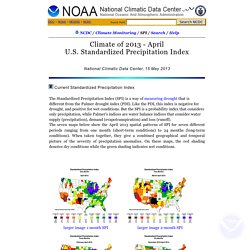
Bike. Area. Agriculture. Airoport. Aerial. U.S. Standardized Precipitation Index. Guttman, N.B., 1991: A sensitivity analysis of the Palmer Hydrologic Drought Index.
Water Resour. Bull., 27, 797-807. Guttman, N.B., 1998: Comparing the Palmer Drought Index and the Standardized Precipitation Index. J. Gardening - Features & Articles. Crop Explorer for Major Crop Regions - Home. NASS - Sorry, the page you requested was not found. MapQuest Maps - Driving Directions - Map. Airports. Appareils et services. TerraFly Geo Databases at FIU sponsored by NSF, USGS, NASA, and IBM. Catalog of Aerial Photography-Earth Sciences & Map Library-University of California, Berkeley. California Air Photo CatalogAir photo coverage at UCB Non-California Air Photos Collections at Other California Locations California Air Photo Catalog Aerial flights are indexed to the county level, not city level.
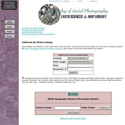
If you don't know the county for your area of interest, search the USGS Geographic Names Information System, then return to this form and submit your search. Keyword queries are limited: they search text only in the flight coverage and flight symbol fields. Although a search on keyword "Berkeley" will retrieve some records, you will miss all flights which cover Berkeley but whose flight description may be "Bay Area," "Alameda County," "Northern California," etc. Return to the search form Air photo coverage at UCB Over 86,000 aerial photographs are available in the Earth Sciences & Map Library.
Collections at Other California Locations Copyright © 2012 The Regents of the University of California. Map Index - Atlapedia Online. Error: Page Not Found. Quick Maps of the World - Flags, Maps, Economy, Geography, Climate, Natural Resources, Current Issues, International Agreements, Population, Social Statistics, Political System. Wall maps, travel maps, atlases, digital maps and more. Lonely Planet's best travel destinations. World Atlas: Maps, Geography, Flags & Facts of Every Country in the World. WORLD ATLAS - World. 3G on W3: The Great Globe Gallery on the World Wide Web. Geonames.usgs.gov/apex/f?p=136:1:0. United States Maps. United States Maps The PCL Map Collection includes more than 250,000 maps, yet less than 30% of the collection is currently online.
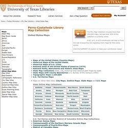
A $5, $15, or $25 contribution will help us fund the cost of acquiring and digitizing more maps for free online access. Click the SUPPORT US button to make your contribution today! State Online Map Collections: Maps of the United States:United States nationalatlas.gov 2003 (3.0MB) [PDF format] United States CIA 2002 (200K) and PDF format (296K) United States CIA 2001 (226K) United States CIA 1999 (159K) United States CIA 1997 (527K) United States CIA 2001 2001 (750K) [PDF format] United States CIA 1999 [PDF format] 1999 (645K) United States (Outline Map) 1998 (75K) United States (Outline Map for Printing) 1998 (75K) United States including Alaska and Hawaii (Outline Map) U.S. United States Maps. TIGER Map Service Removal. The 1990 TIGER Map Service was retired in May 2010.
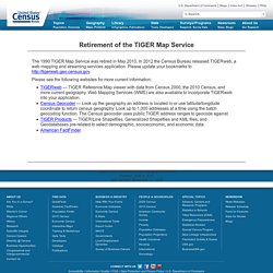
In 2012 the Census Bureau released TIGERweb, a web mapping and streaming services application. Please update your bookmarks to Please see the following websites for more current information: TIGERweb — TIGER Reference Map viewer with data from Census 2000, the 2010 Census, and more current geography. Web Mapping Services (WMS) are also available to incorporate TIGERweb into your application. Rand McNally - Page Not Found. The National Map: Small Scale. The National Map is now offering a collection of small-scale datasets that can be downloaded for free.
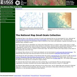
Although the 1997-2014 Edition of the National Atlas of the United States was retired in September 2014, The National Map recognizes the importance of continuing to make a collection of the small-scale datasets, originally developed for the National Atlas, available to users. Small-scale maps have an advantage over large-scale maps when there is a need to show a large area in a single view. This makes small-scale maps an ideal solution for scientists, decision-makers, and planners needing to provide a geographical context for the research projects.
Generally, certain geographical and feature details found in large-scale maps are limited or omitted in small-scale maps. The choice of small-scale maps always comes down to the intended use of the final map. Map Collection - World Sites Atlas. World Atlas A physical and a political map of the world, divided into tiles for easy navigation.
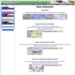
Maps of Continents and Regions Select a continent or region below to jump to its map. From there, click on a country name to get maps, hotels, and information.Here is a complete list of links. Maps of Countries and Territories Use the drop-down list below to jump to map for that country or territory (a few do not have maps yet).Click here for a complete list of country maps. Maps of U.S. Use the drop-down list below to jump to the map page for that state or province.Here is a list of all the state and province map pages. Maps - National Geographic. Map Collections Home Page. Perry-Castañeda Library Map Collection - UT Library Online. Traduction - بحث Google